You are here: Home > Network List > AV - Alaska Volcano Observatory Stations List
> Station PLK3 Mt. Peulik Volcano 3, Alaska > Earthquake Result Viewer
PLK3 Mt. Peulik Volcano 3, Alaska - Earthquake Result Viewer
| Earthquake location: |
Kermadec Islands, New Zealand |
| Earthquake latitude/longitude: |
-29.7/-177.3 |
| Earthquake time(UTC): |
2021/03/04 (063) 19:28:31 GMT |
| Earthquake Depth: |
19 km |
| Earthquake Magnitude: |
8.1 mww |
| Earthquake Catalog/Contributor: |
NEIC PDE/us |
|
| Network: |
AV Alaska Volcano Observatory |
| Station: |
PLK3 Mt. Peulik Volcano 3, Alaska |
| Lat/Lon: |
57.69 N/156.27 W |
| Elevation: |
494 m |
|
| Distance: |
88.9 deg |
| Az: |
11.098 deg |
| Baz: |
198.162 deg |
| Ray Param: |
0.042253464 |
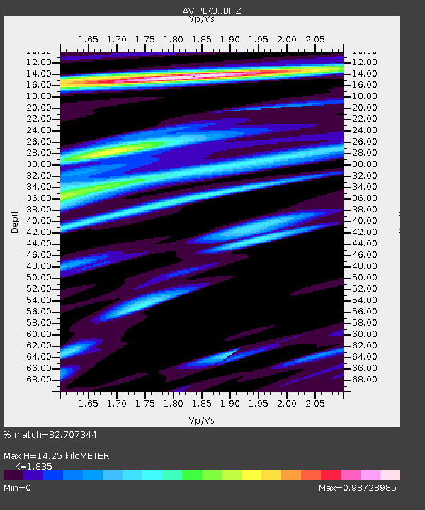
| Estimated Moho Depth: |
14.25 km |
| Estimated Crust Vp/Vs: |
1.84 |
| Assumed Crust Vp: |
6.1 km/s |
| Estimated Crust Vs: |
3.324 km/s |
| Estimated Crust Poisson's Ratio: |
0.29 |
|
| Radial Match: |
82.707344 % |
| Radial Bump: |
400 |
| Transverse Match: |
73.138336 % |
| Transverse Bump: |
400 |
| SOD ConfigId: |
23341671 |
| Insert Time: |
2021-03-18 20:47:03.283 +0000 |
| GWidth: |
2.5 |
| Max Bumps: |
400 |
| Tol: |
0.001 |
|

Signal To Noise
| Channel | StoN | STA | LTA |
| AV:PLK3: :BHZ:20210304T19:40:53.059001Z | 3.3071957 | 1.6399232E-6 | 4.958652E-7 |
| AV:PLK3: :BHN:20210304T19:40:53.059001Z | 1.7007233 | 1.5209761E-6 | 8.9431126E-7 |
| AV:PLK3: :BHE:20210304T19:40:53.059001Z | 1.5458508 | 2.659917E-6 | 1.7206818E-6 |
| Arrivals |
| Ps | 2.0 SECOND |
| PpPs | 6.5 SECOND |
| PsPs/PpSs | 8.5 SECOND |


