You are here: Home > Network List > AV - Alaska Volcano Observatory Stations List
> Station SPBG Barrier Glacier, Mount Spurr, Alaska > Earthquake Result Viewer
SPBG Barrier Glacier, Mount Spurr, Alaska - Earthquake Result Viewer
| Earthquake location: |
Kermadec Islands, New Zealand |
| Earthquake latitude/longitude: |
-29.7/-177.3 |
| Earthquake time(UTC): |
2021/03/04 (063) 19:28:31 GMT |
| Earthquake Depth: |
19 km |
| Earthquake Magnitude: |
8.1 mww |
| Earthquake Catalog/Contributor: |
NEIC PDE/us |
|
| Network: |
AV Alaska Volcano Observatory |
| Station: |
SPBG Barrier Glacier, Mount Spurr, Alaska |
| Lat/Lon: |
61.26 N/152.37 W |
| Elevation: |
1087 m |
|
| Distance: |
92.9 deg |
| Az: |
11.755 deg |
| Baz: |
201.505 deg |
| Ray Param: |
0.041369166 |
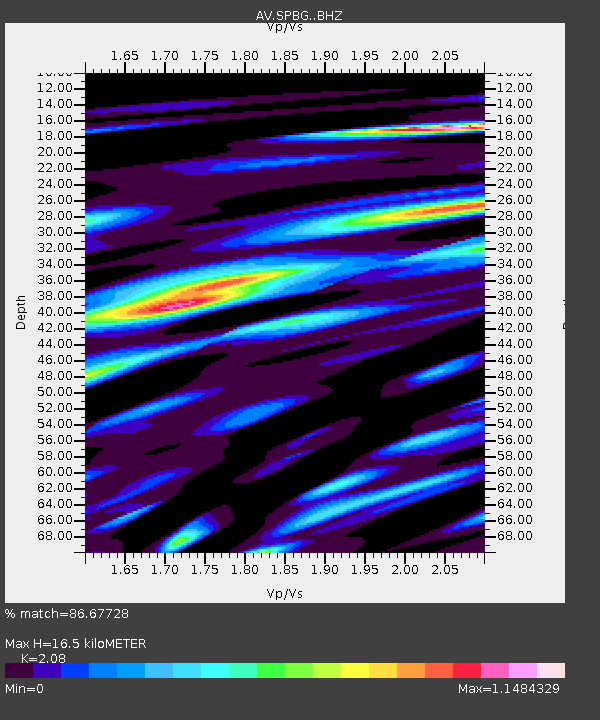
| Estimated Moho Depth: |
16.5 km |
| Estimated Crust Vp/Vs: |
2.08 |
| Assumed Crust Vp: |
6.566 km/s |
| Estimated Crust Vs: |
3.157 km/s |
| Estimated Crust Poisson's Ratio: |
0.35 |
|
| Radial Match: |
86.67728 % |
| Radial Bump: |
400 |
| Transverse Match: |
76.48455 % |
| Transverse Bump: |
400 |
| SOD ConfigId: |
23341671 |
| Insert Time: |
2021-03-18 20:47:09.758 +0000 |
| GWidth: |
2.5 |
| Max Bumps: |
400 |
| Tol: |
0.001 |
|

Signal To Noise
| Channel | StoN | STA | LTA |
| AV:SPBG: :BHZ:20210304T19:41:11.75999Z | 2.226691 | 2.927072E-6 | 1.314539E-6 |
| AV:SPBG: :BHN:20210304T19:41:11.75999Z | 1.1701006 | 6.7986554E-7 | 5.810317E-7 |
| AV:SPBG: :BHE:20210304T19:41:11.75999Z | 0.9670796 | 9.173887E-7 | 9.4861764E-7 |
| Arrivals |
| Ps | 2.8 SECOND |
| PpPs | 7.6 SECOND |
| PsPs/PpSs | 10 SECOND |


