You are here: Home > Network List > IU - Global Seismograph Network (GSN - IRIS/USGS) Stations List
> Station INCN Inchon, Republic of Korea > Earthquake Result Viewer
INCN Inchon, Republic of Korea - Earthquake Result Viewer
| Earthquake location: |
Kermadec Islands, New Zealand |
| Earthquake latitude/longitude: |
-29.7/-177.3 |
| Earthquake time(UTC): |
2021/03/04 (063) 19:28:31 GMT |
| Earthquake Depth: |
19 km |
| Earthquake Magnitude: |
8.1 mww |
| Earthquake Catalog/Contributor: |
NEIC PDE/us |
|
| Network: |
IU Global Seismograph Network (GSN - IRIS/USGS) |
| Station: |
INCN Inchon, Republic of Korea |
| Lat/Lon: |
37.48 N/126.62 E |
| Elevation: |
55 m |
|
| Distance: |
85.0 deg |
| Az: |
318.479 deg |
| Baz: |
133.558 deg |
| Ray Param: |
0.045052025 |
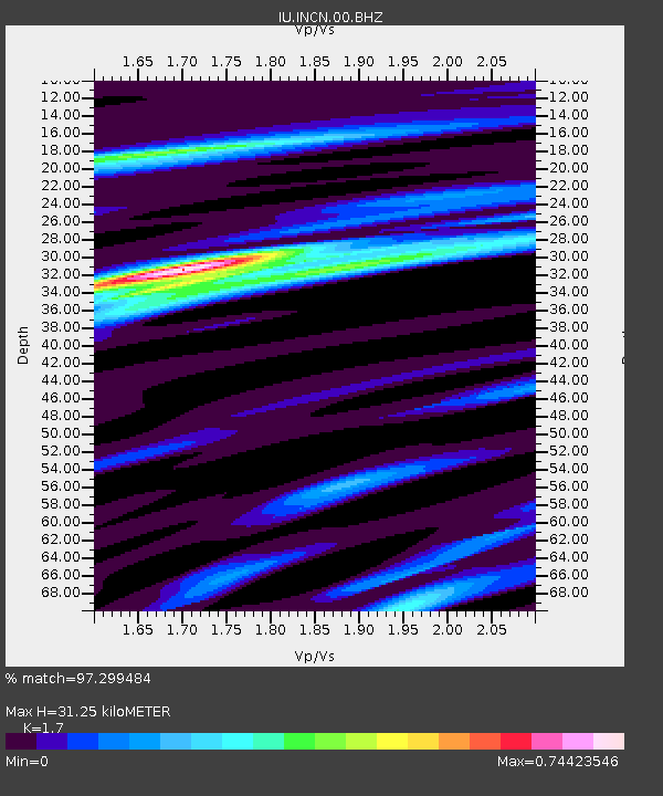
| Estimated Moho Depth: |
31.25 km |
| Estimated Crust Vp/Vs: |
1.70 |
| Assumed Crust Vp: |
6.459 km/s |
| Estimated Crust Vs: |
3.8 km/s |
| Estimated Crust Poisson's Ratio: |
0.24 |
|
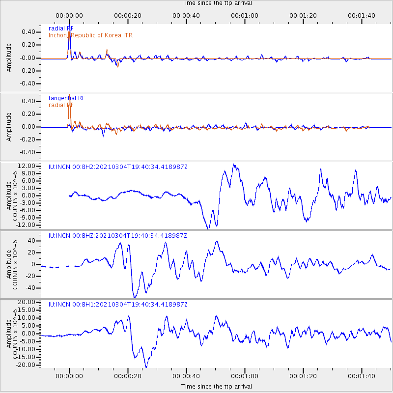
| Radial Match: |
97.299484 % |
| Radial Bump: |
319 |
| Transverse Match: |
93.82653 % |
| Transverse Bump: |
390 |
| SOD ConfigId: |
23341671 |
| Insert Time: |
2021-03-18 20:52:35.379 +0000 |
| GWidth: |
2.5 |
| Max Bumps: |
400 |
| Tol: |
0.001 |
|
Signal To Noise
| Channel | StoN | STA | LTA |
| IU:INCN:00:BHZ:20210304T19:40:34.418987Z | 1.2173382 | 1.6421639E-6 | 1.3489791E-6 |
| IU:INCN:00:BH1:20210304T19:40:34.418987Z | 0.76720524 | 4.5638E-7 | 5.948604E-7 |
| IU:INCN:00:BH2:20210304T19:40:34.418987Z | 0.7084513 | 8.755035E-7 | 1.235799E-6 |
| Arrivals |
| Ps | 3.5 SECOND |
| PpPs | 13 SECOND |
| PsPs/PpSs | 16 SECOND |


