You are here: Home > Network List > JP - Japan Meteorological Agency Seismic Network Stations List
> Station JCJ Chichijima Island > Earthquake Result Viewer
JCJ Chichijima Island - Earthquake Result Viewer
| Earthquake location: |
Kermadec Islands, New Zealand |
| Earthquake latitude/longitude: |
-29.7/-177.3 |
| Earthquake time(UTC): |
2021/03/04 (063) 19:28:31 GMT |
| Earthquake Depth: |
19 km |
| Earthquake Magnitude: |
8.1 mww |
| Earthquake Catalog/Contributor: |
NEIC PDE/us |
|
| Network: |
JP Japan Meteorological Agency Seismic Network |
| Station: |
JCJ Chichijima Island |
| Lat/Lon: |
27.10 N/142.18 E |
| Elevation: |
150 m |
|
| Distance: |
68.6 deg |
| Az: |
321.492 deg |
| Baz: |
142.596 deg |
| Ray Param: |
0.056209724 |
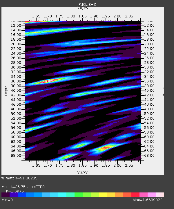
| Estimated Moho Depth: |
35.75 km |
| Estimated Crust Vp/Vs: |
1.70 |
| Assumed Crust Vp: |
4.24 km/s |
| Estimated Crust Vs: |
2.498 km/s |
| Estimated Crust Poisson's Ratio: |
0.23 |
|
| Radial Match: |
91.38205 % |
| Radial Bump: |
400 |
| Transverse Match: |
85.43861 % |
| Transverse Bump: |
400 |
| SOD ConfigId: |
23341671 |
| Insert Time: |
2021-03-18 20:52:48.446 +0000 |
| GWidth: |
2.5 |
| Max Bumps: |
400 |
| Tol: |
0.001 |
|

Signal To Noise
| Channel | StoN | STA | LTA |
| JP:JCJ: :BHZ:20210304T19:39:01.900005Z | 2.475633 | 5.9945583E-6 | 2.4214246E-6 |
| JP:JCJ: :BHN:20210304T19:39:01.900005Z | 0.59533256 | 2.3166415E-6 | 3.89134E-6 |
| JP:JCJ: :BHE:20210304T19:39:01.900005Z | 0.7845337 | 2.6465034E-6 | 3.3733459E-6 |
| Arrivals |
| Ps | 6.0 SECOND |
| PpPs | 22 SECOND |
| PsPs/PpSs | 28 SECOND |


