You are here: Home > Network List > UU - University of Utah Regional Network Stations List
> Station CVRU Castle Valley Ranch, Emery, UT, USA old TA-Q16A > Earthquake Result Viewer
CVRU Castle Valley Ranch, Emery, UT, USA old TA-Q16A - Earthquake Result Viewer
| Earthquake location: |
North Of Franz Josef Land |
| Earthquake latitude/longitude: |
86.9/54.5 |
| Earthquake time(UTC): |
2017/10/28 (301) 16:13:54 GMT |
| Earthquake Depth: |
10 km |
| Earthquake Magnitude: |
5.8 Mww |
| Earthquake Catalog/Contributor: |
NEIC PDE/us |
|
| Network: |
UU University of Utah Regional Network |
| Station: |
CVRU Castle Valley Ranch, Emery, UT, USA old TA-Q16A |
| Lat/Lon: |
38.92 N/111.17 W |
| Elevation: |
1912 m |
|
| Distance: |
54.3 deg |
| Az: |
346.244 deg |
| Baz: |
0.954 deg |
| Ray Param: |
0.06552931 |
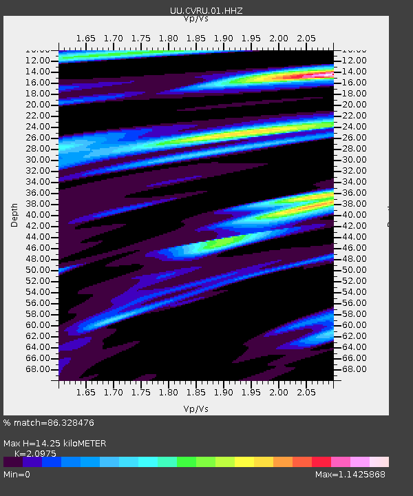
| Estimated Moho Depth: |
14.25 km |
| Estimated Crust Vp/Vs: |
2.10 |
| Assumed Crust Vp: |
6.207 km/s |
| Estimated Crust Vs: |
2.959 km/s |
| Estimated Crust Poisson's Ratio: |
0.35 |
|
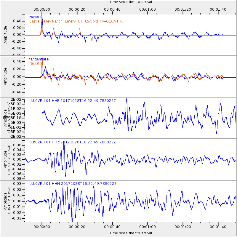
| Radial Match: |
86.328476 % |
| Radial Bump: |
389 |
| Transverse Match: |
60.560837 % |
| Transverse Bump: |
355 |
| SOD ConfigId: |
2364251 |
| Insert Time: |
2017-11-11 16:19:32.070 +0000 |
| GWidth: |
2.5 |
| Max Bumps: |
400 |
| Tol: |
0.001 |
|
Signal To Noise
| Channel | StoN | STA | LTA |
| UU:CVRU:01:HHZ:20171028T16:22:49.788022Z | 1.8074242 | 1.1463341E-8 | 6.3423635E-9 |
| UU:CVRU:01:HHN:20171028T16:22:49.788022Z | 1.7313464 | 5.067519E-9 | 2.9269236E-9 |
| UU:CVRU:01:HHE:20171028T16:22:49.788022Z | 0.8430252 | 3.7682306E-9 | 4.469891E-9 |
| Arrivals |
| Ps | 2.6 SECOND |
| PpPs | 6.8 SECOND |
| PsPs/PpSs | 9.4 SECOND |


