You are here: Home > Network List > UU - University of Utah Regional Network Stations List
> Station KNB Kanab, UT, USA > Earthquake Result Viewer
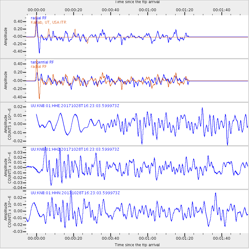
KNB Kanab, UT, USA - Earthquake Result Viewer
*The percent match for this event was below the threshold and hence no stack was calculated.
| Earthquake location: |
North Of Franz Josef Land |
| Earthquake latitude/longitude: |
86.9/54.5 |
| Earthquake time(UTC): |
2017/10/28 (301) 16:13:54 GMT |
| Earthquake Depth: |
10 km |
| Earthquake Magnitude: |
5.8 Mww |
| Earthquake Catalog/Contributor: |
NEIC PDE/us |
|
| Network: |
UU University of Utah Regional Network |
| Station: |
KNB Kanab, UT, USA |
| Lat/Lon: |
37.02 N/112.82 W |
| Elevation: |
1715 m |
|
| Distance: |
56.2 deg |
| Az: |
347.795 deg |
| Baz: |
0.827 deg |
| Ray Param: |
$rayparam |
*The percent match for this event was below the threshold and hence was not used in the summary stack. |
|
| Radial Match: |
66.11209 % |
| Radial Bump: |
295 |
| Transverse Match: |
71.27814 % |
| Transverse Bump: |
400 |
| SOD ConfigId: |
2364251 |
| Insert Time: |
2017-11-11 16:19:39.417 +0000 |
| GWidth: |
2.5 |
| Max Bumps: |
400 |
| Tol: |
0.001 |
|
Signal To Noise
| Channel | StoN | STA | LTA |
| UU:KNB:01:HHZ:20171028T16:23:03.599973Z | 2.576855 | 1.3786703E-8 | 5.3502056E-9 |
| UU:KNB:01:HHN:20171028T16:23:03.599973Z | 1.5344408 | 7.3657827E-9 | 4.800304E-9 |
| UU:KNB:01:HHE:20171028T16:23:03.599973Z | 0.4736607 | 3.2488177E-9 | 6.858955E-9 |
| Arrivals |
| Ps | |
| PpPs | |
| PsPs/PpSs | |


