You are here: Home > Network List > TA - USArray Transportable Network (new EarthScope stations) Stations List
> Station O15K Ungalikthiuk River, AK, USA > Earthquake Result Viewer
O15K Ungalikthiuk River, AK, USA - Earthquake Result Viewer
| Earthquake location: |
Kermadec Islands, New Zealand |
| Earthquake latitude/longitude: |
-29.7/-177.3 |
| Earthquake time(UTC): |
2021/03/04 (063) 19:28:31 GMT |
| Earthquake Depth: |
19 km |
| Earthquake Magnitude: |
8.1 mww |
| Earthquake Catalog/Contributor: |
NEIC PDE/us |
|
| Network: |
TA USArray Transportable Network (new EarthScope stations) |
| Station: |
O15K Ungalikthiuk River, AK, USA |
| Lat/Lon: |
59.18 N/159.82 W |
| Elevation: |
306 m |
|
| Distance: |
89.8 deg |
| Az: |
8.879 deg |
| Baz: |
195.112 deg |
| Ray Param: |
0.041731674 |
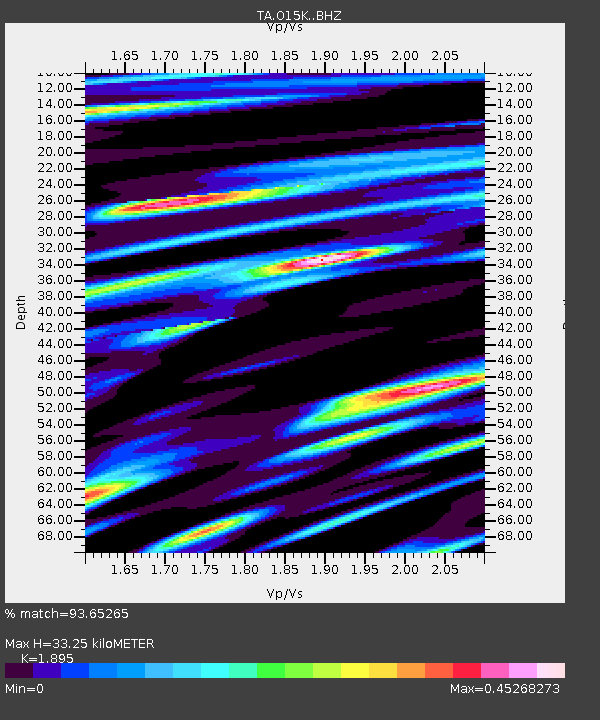
| Estimated Moho Depth: |
33.25 km |
| Estimated Crust Vp/Vs: |
1.89 |
| Assumed Crust Vp: |
6.24 km/s |
| Estimated Crust Vs: |
3.293 km/s |
| Estimated Crust Poisson's Ratio: |
0.31 |
|
| Radial Match: |
93.65265 % |
| Radial Bump: |
400 |
| Transverse Match: |
64.76327 % |
| Transverse Bump: |
400 |
| SOD ConfigId: |
23341671 |
| Insert Time: |
2021-03-18 20:55:36.023 +0000 |
| GWidth: |
2.5 |
| Max Bumps: |
400 |
| Tol: |
0.001 |
|

Signal To Noise
| Channel | StoN | STA | LTA |
| TA:O15K: :BHZ:20210304T19:40:57.225017Z | 1.8885866 | 3.1260886E-6 | 1.6552528E-6 |
| TA:O15K: :BHN:20210304T19:40:57.225017Z | 1.468238 | 1.7427982E-6 | 1.1869998E-6 |
| TA:O15K: :BHE:20210304T19:40:57.225017Z | 2.554756 | 3.6650993E-6 | 1.4346181E-6 |
| Arrivals |
| Ps | 4.9 SECOND |
| PpPs | 15 SECOND |
| PsPs/PpSs | 20 SECOND |


