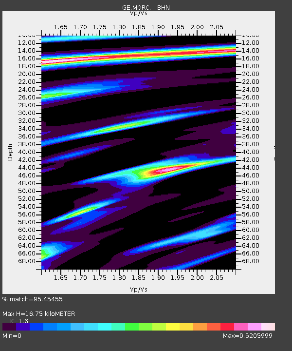
MORC GEOFON Station Moravsky Beroun, Czech Republic - Earthquake Result Viewer

Earthquake location: Andreanof Islands, Aleutian Is.
Earthquake latitude/longitude: 51.2/-179.8
Earthquake time(UTC): 2001/06/14 (165) 19:48:47 GMT
Earthquake Depth: 18 km
Earthquake Magnitude: 6.0 MB, 6.3 MS, 6.5 MW, 6.1 ML
Earthquake Catalog/Contributor: WHDF/NEIC
Network: GE GEOFON
Station: MORC GEOFON Station Moravsky Beroun, Czech Republic
Lat/Lon: 49.78 N/17.54 E
Elevation: 740 m
Distance: 78.4 deg
Az: 348.602 deg
Baz: 11.067 deg
Ray Param: 0.04968373
Estimated Moho Depth: 16.75 km
Estimated Crust Vp/Vs: 1.60
Assumed Crust Vp: 6.276 km/s
Estimated Crust Vs: 3.922 km/s
Estimated Crust Poisson's Ratio: 0.18
Radial Match: 95.45455 %
Radial Bump: 400
Transverse Match: 72.1067 %
Transverse Bump: 400
SOD ConfigId: 4714
Insert Time: 2010-03-09 05:59:11.286 +0000
GWidth: 2.5
Max Bumps: 400
Tol: 0.001

Signal To Noise

ChannelStoNSTALTA
GE:MORC: :BHN:20010614T20:00:15.659998Z5.9527354.262603E-77.160747E-8
GE:MORC: :BHE:20010614T20:00:15.659998Z2.27117281.1893678E-75.2368E-8
GE:MORC: :BHZ:20010614T20:00:15.659998Z19.485999.561103E-74.9066546E-8
Arrivals
Ps1.7 SECOND
PpPs6.7 SECOND
PsPs/PpSs8.4 SECOND