You are here: Home > Network List > HV - Hawaiian Volcano Observatory Network Stations List
> Station OBL Observatory Bluff > Earthquake Result Viewer
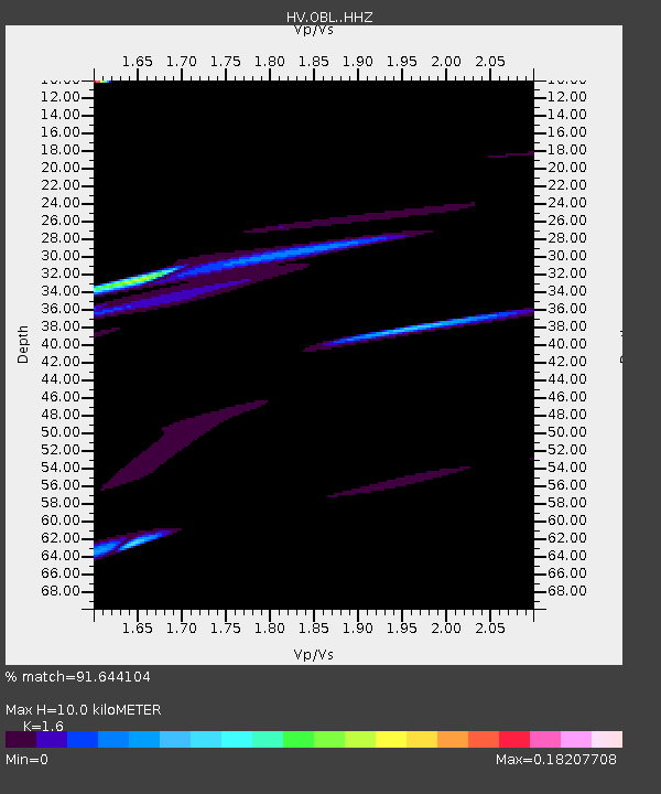
OBL Observatory Bluff - Earthquake Result Viewer
| Earthquake location: |
Kermadec Islands Region |
| Earthquake latitude/longitude: |
-28.9/-176.9 |
| Earthquake time(UTC): |
2021/03/04 (063) 19:43:45 GMT |
| Earthquake Depth: |
10 km |
| Earthquake Magnitude: |
5.6 mb |
| Earthquake Catalog/Contributor: |
NEIC PDE/us |
|
| Network: |
HV Hawaiian Volcano Observatory Network |
| Station: |
OBL Observatory Bluff |
| Lat/Lon: |
19.42 N/155.28 W |
| Elevation: |
1119 m |
|
| Distance: |
52.4 deg |
| Az: |
26.038 deg |
| Baz: |
204.063 deg |
| Ray Param: |
0.06677994 |
| Estimated Moho Depth: |
10.0 km |
| Estimated Crust Vp/Vs: |
1.60 |
| Assumed Crust Vp: |
5.195 km/s |
| Estimated Crust Vs: |
3.247 km/s |
| Estimated Crust Poisson's Ratio: |
0.18 |
|
| Radial Match: |
91.644104 % |
| Radial Bump: |
364 |
| Transverse Match: |
52.62595 % |
| Transverse Bump: |
400 |
| SOD ConfigId: |
23341671 |
| Insert Time: |
2021-03-18 21:19:10.611 +0000 |
| GWidth: |
2.5 |
| Max Bumps: |
400 |
| Tol: |
0.001 |
|

Signal To Noise
| Channel | StoN | STA | LTA |
| HV:OBL: :HHZ:20210304T19:52:27.223975Z | 1.4999245 | 1.8366757E-4 | 1.224512E-4 |
| HV:OBL: :HHN:20210304T19:52:27.223975Z | 3.2002661 | 2.9235866E-4 | 9.1354486E-5 |
| HV:OBL: :HHE:20210304T19:52:27.223975Z | 2.0435305 | 8.44315E-5 | 4.131649E-5 |
| Arrivals |
| Ps | 1.2 SECOND |
| PpPs | 4.8 SECOND |
| PsPs/PpSs | 6.0 SECOND |


