You are here: Home > Network List > TX - Texas Seismological Network Stations List
> Station WTFS Witchita Falls > Earthquake Result Viewer
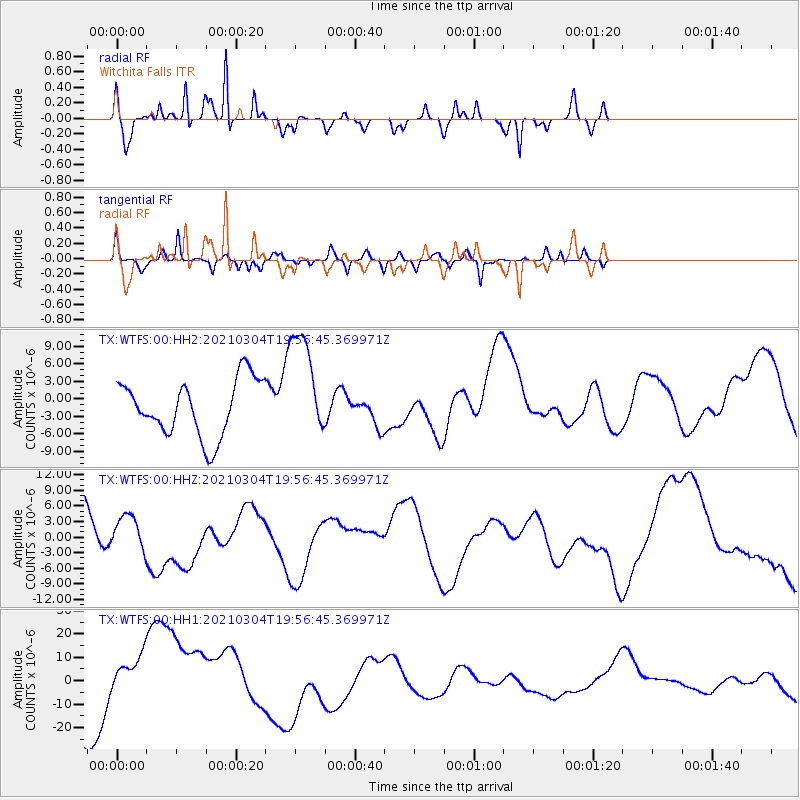
WTFS Witchita Falls - Earthquake Result Viewer
*The percent match for this event was below the threshold and hence no stack was calculated.
| Earthquake location: |
Kermadec Islands Region |
| Earthquake latitude/longitude: |
-28.9/-176.9 |
| Earthquake time(UTC): |
2021/03/04 (063) 19:43:45 GMT |
| Earthquake Depth: |
10 km |
| Earthquake Magnitude: |
5.6 mb |
| Earthquake Catalog/Contributor: |
NEIC PDE/us |
|
| Network: |
TX Texas Seismological Network |
| Station: |
WTFS Witchita Falls |
| Lat/Lon: |
33.77 N/98.46 W |
| Elevation: |
277 m |
|
| Distance: |
96.9 deg |
| Az: |
55.291 deg |
| Baz: |
239.897 deg |
| Ray Param: |
$rayparam |
*The percent match for this event was below the threshold and hence was not used in the summary stack. |
|
| Radial Match: |
56.14896 % |
| Radial Bump: |
236 |
| Transverse Match: |
56.331623 % |
| Transverse Bump: |
300 |
| SOD ConfigId: |
23341671 |
| Insert Time: |
2021-03-18 21:24:05.259 +0000 |
| GWidth: |
2.5 |
| Max Bumps: |
400 |
| Tol: |
0.001 |
|
Signal To Noise
| Channel | StoN | STA | LTA |
| TX:WTFS:00:HHZ:20210304T19:56:45.369971Z | 0.51355904 | 4.499516E-6 | 8.761438E-6 |
| TX:WTFS:00:HH1:20210304T19:56:45.369971Z | 1.4351077 | 1.2210285E-5 | 8.508271E-6 |
| TX:WTFS:00:HH2:20210304T19:56:45.369971Z | 1.9853889 | 9.489309E-6 | 4.779572E-6 |
| Arrivals |
| Ps | |
| PpPs | |
| PsPs/PpSs | |


