You are here: Home > Network List > GS - US Geological Survey Networks Stations List
> Station KAN10 Keim Farm > Earthquake Result Viewer
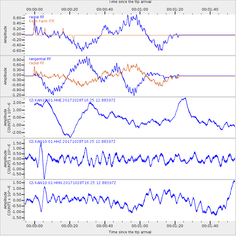
KAN10 Keim Farm - Earthquake Result Viewer
*The percent match for this event was below the threshold and hence no stack was calculated.
| Earthquake location: |
North Of Franz Josef Land |
| Earthquake latitude/longitude: |
86.9/52.8 |
| Earthquake time(UTC): |
2017/10/28 (301) 16:16:06 GMT |
| Earthquake Depth: |
10 km |
| Earthquake Magnitude: |
5.8 Mww |
| Earthquake Catalog/Contributor: |
NEIC PDE/us |
|
| Network: |
GS US Geological Survey Networks |
| Station: |
KAN10 Keim Farm |
| Lat/Lon: |
37.12 N/98.10 W |
| Elevation: |
417 m |
|
| Distance: |
55.8 deg |
| Az: |
332.013 deg |
| Baz: |
1.836 deg |
| Ray Param: |
$rayparam |
*The percent match for this event was below the threshold and hence was not used in the summary stack. |
|
| Radial Match: |
34.961506 % |
| Radial Bump: |
400 |
| Transverse Match: |
31.927809 % |
| Transverse Bump: |
400 |
| SOD ConfigId: |
2364251 |
| Insert Time: |
2017-11-11 16:21:54.927 +0000 |
| GWidth: |
2.5 |
| Max Bumps: |
400 |
| Tol: |
0.001 |
|
Signal To Noise
| Channel | StoN | STA | LTA |
| GS:KAN10:01:HHZ:20171028T16:25:12.88397Z | 2.4235973 | 6.8341524E-7 | 2.8198383E-7 |
| GS:KAN10:01:HHN:20171028T16:25:12.88397Z | 0.88813174 | 4.337294E-7 | 4.883616E-7 |
| GS:KAN10:01:HHE:20171028T16:25:12.88397Z | 0.89890987 | 1.5535363E-6 | 1.7282448E-6 |
| Arrivals |
| Ps | |
| PpPs | |
| PsPs/PpSs | |


