You are here: Home > Network List > TA - USArray Transportable Network (new EarthScope stations) Stations List
> Station I17K Unalakleet, AK, USA > Earthquake Result Viewer
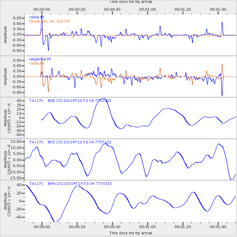
I17K Unalakleet, AK, USA - Earthquake Result Viewer
*The percent match for this event was below the threshold and hence no stack was calculated.
| Earthquake location: |
Kermadec Islands, New Zealand |
| Earthquake latitude/longitude: |
-29.8/-177.2 |
| Earthquake time(UTC): |
2021/03/04 (063) 19:46:17 GMT |
| Earthquake Depth: |
10 km |
| Earthquake Magnitude: |
5.7 mb |
| Earthquake Catalog/Contributor: |
NEIC PDE/us |
|
| Network: |
TA USArray Transportable Network (new EarthScope stations) |
| Station: |
I17K Unalakleet, AK, USA |
| Lat/Lon: |
63.89 N/160.70 W |
| Elevation: |
105 m |
|
| Distance: |
94.3 deg |
| Az: |
7.251 deg |
| Baz: |
194.356 deg |
| Ray Param: |
$rayparam |
*The percent match for this event was below the threshold and hence was not used in the summary stack. |
|
| Radial Match: |
68.32217 % |
| Radial Bump: |
375 |
| Transverse Match: |
74.14087 % |
| Transverse Bump: |
346 |
| SOD ConfigId: |
23341671 |
| Insert Time: |
2021-03-18 21:38:14.505 +0000 |
| GWidth: |
2.5 |
| Max Bumps: |
400 |
| Tol: |
0.001 |
|
Signal To Noise
| Channel | StoN | STA | LTA |
| TA:I17K: :BHZ:20210304T19:59:04.775016Z | 0.20929754 | 3.1568545E-6 | 1.5083095E-5 |
| TA:I17K: :BHN:20210304T19:59:04.775016Z | 1.1376675 | 2.421991E-5 | 2.1289092E-5 |
| TA:I17K: :BHE:20210304T19:59:04.775016Z | 4.2787337 | 3.902583E-5 | 9.120883E-6 |
| Arrivals |
| Ps | |
| PpPs | |
| PsPs/PpSs | |


