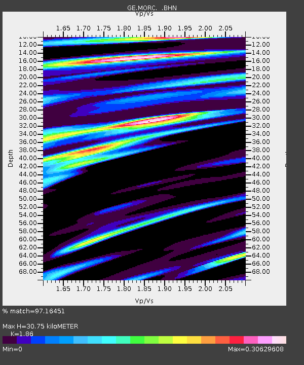
MORC GEOFON Station Moravsky Beroun, Czech Republic - Earthquake Result Viewer

Earthquake location: Near West Coast Of Colombia
Earthquake latitude/longitude: 4.7/-77.5
Earthquake time(UTC): 2004/11/15 (320) 09:06:56 GMT
Earthquake Depth: 15 km
Earthquake Magnitude: 6.6 MB, 7.1 MS, 7.2 MW, 7.1 MW
Earthquake Catalog/Contributor: WHDF/NEIC
Network: GE GEOFON
Station: MORC GEOFON Station Moravsky Beroun, Czech Republic
Lat/Lon: 49.78 N/17.54 E
Elevation: 740 m
Distance: 89.7 deg
Az: 40.225 deg
Baz: 276.865 deg
Ray Param: 0.041724324
Estimated Moho Depth: 30.75 km
Estimated Crust Vp/Vs: 1.86
Assumed Crust Vp: 6.276 km/s
Estimated Crust Vs: 3.374 km/s
Estimated Crust Poisson's Ratio: 0.30
Radial Match: 97.16451 %
Radial Bump: 352
Transverse Match: 81.949 %
Transverse Bump: 400
SOD ConfigId: 2459
Insert Time: 2010-03-09 06:00:37.284 +0000
GWidth: 2.5
Max Bumps: 400
Tol: 0.001

Signal To Noise

ChannelStoNSTALTA
GE:MORC: :BHN:20041115T09:19:22.421023Z2.80125579.418541E-73.362257E-7
GE:MORC: :BHE:20041115T09:19:22.421023Z25.2122123.1191048E-61.2371405E-7
GE:MORC: :BHZ:20041115T09:19:22.421023Z21.6048281.1738607E-55.433326E-7
Arrivals
Ps4.3 SECOND
PpPs14 SECOND
PsPs/PpSs18 SECOND