You are here: Home > Network List > US - United States National Seismic Network Stations List
> Station MNTX Cornudas Mountains, Texas, USA > Earthquake Result Viewer
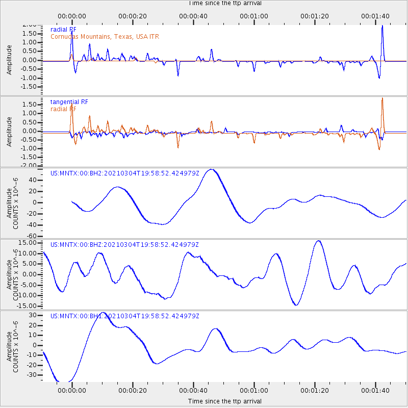
MNTX Cornudas Mountains, Texas, USA - Earthquake Result Viewer
*The percent match for this event was below the threshold and hence no stack was calculated.
| Earthquake location: |
Kermadec Islands, New Zealand |
| Earthquake latitude/longitude: |
-29.8/-177.2 |
| Earthquake time(UTC): |
2021/03/04 (063) 19:46:17 GMT |
| Earthquake Depth: |
10 km |
| Earthquake Magnitude: |
5.7 mb |
| Earthquake Catalog/Contributor: |
NEIC PDE/us |
|
| Network: |
US United States National Seismic Network |
| Station: |
MNTX Cornudas Mountains, Texas, USA |
| Lat/Lon: |
31.70 N/105.38 W |
| Elevation: |
404 m |
|
| Distance: |
91.6 deg |
| Az: |
54.119 deg |
| Baz: |
235.72 deg |
| Ray Param: |
$rayparam |
*The percent match for this event was below the threshold and hence was not used in the summary stack. |
|
| Radial Match: |
31.30739 % |
| Radial Bump: |
266 |
| Transverse Match: |
36.771503 % |
| Transverse Bump: |
357 |
| SOD ConfigId: |
23341671 |
| Insert Time: |
2021-03-18 21:40:47.827 +0000 |
| GWidth: |
2.5 |
| Max Bumps: |
400 |
| Tol: |
0.001 |
|
Signal To Noise
| Channel | StoN | STA | LTA |
| US:MNTX:00:BHZ:20210304T19:58:52.424979Z | 0.6075384 | 4.8644442E-6 | 8.006809E-6 |
| US:MNTX:00:BH1:20210304T19:58:52.424979Z | 1.9906144 | 2.5627025E-5 | 1.2873927E-5 |
| US:MNTX:00:BH2:20210304T19:58:52.424979Z | 2.0124404 | 3.428935E-5 | 1.703869E-5 |
| Arrivals |
| Ps | |
| PpPs | |
| PsPs/PpSs | |


