You are here: Home > Network List > AK - Alaska Regional Network Stations List
> Station BAGL Bagley Icefield, AK, USA > Earthquake Result Viewer
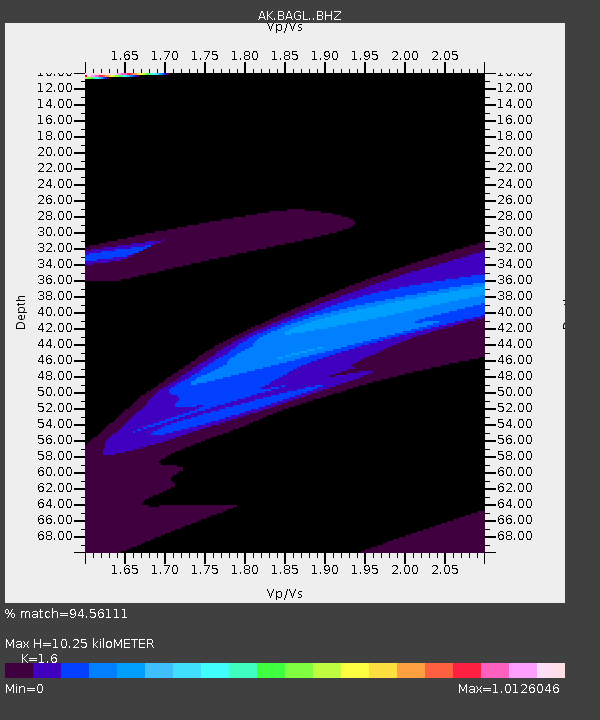
BAGL Bagley Icefield, AK, USA - Earthquake Result Viewer
| Earthquake location: |
Kermadec Islands Region |
| Earthquake latitude/longitude: |
-29.1/-176.7 |
| Earthquake time(UTC): |
2021/03/04 (063) 20:20:43 GMT |
| Earthquake Depth: |
10 km |
| Earthquake Magnitude: |
5.5 mb |
| Earthquake Catalog/Contributor: |
NEIC PDE/us |
|
| Network: |
AK Alaska Regional Network |
| Station: |
BAGL Bagley Icefield, AK, USA |
| Lat/Lon: |
60.49 N/142.09 W |
| Elevation: |
1470 m |
|
| Distance: |
93.6 deg |
| Az: |
16.367 deg |
| Baz: |
209.892 deg |
| Ray Param: |
0.041231375 |
| Estimated Moho Depth: |
10.25 km |
| Estimated Crust Vp/Vs: |
1.60 |
| Assumed Crust Vp: |
6.566 km/s |
| Estimated Crust Vs: |
4.104 km/s |
| Estimated Crust Poisson's Ratio: |
0.18 |
|
| Radial Match: |
94.56111 % |
| Radial Bump: |
400 |
| Transverse Match: |
87.65621 % |
| Transverse Bump: |
243 |
| SOD ConfigId: |
23341671 |
| Insert Time: |
2021-03-18 21:43:48.431 +0000 |
| GWidth: |
2.5 |
| Max Bumps: |
400 |
| Tol: |
0.001 |
|

Signal To Noise
| Channel | StoN | STA | LTA |
| AK:BAGL: :BHZ:20210304T20:33:28.408006Z | 1.413375 | 8.21872E-5 | 5.814961E-5 |
| AK:BAGL: :BHN:20210304T20:33:28.408006Z | 0.7787099 | 3.6295845E-5 | 4.6610225E-5 |
| AK:BAGL: :BHE:20210304T20:33:28.408006Z | 2.2969744 | 5.2129275E-5 | 2.2694756E-5 |
| Arrivals |
| Ps | 1.0 SECOND |
| PpPs | 4.0 SECOND |
| PsPs/PpSs | 4.9 SECOND |


