You are here: Home > Network List > AK - Alaska Regional Network Stations List
> Station H24K Noodor Dome, AK, USA > Earthquake Result Viewer
H24K Noodor Dome, AK, USA - Earthquake Result Viewer
| Earthquake location: |
Kermadec Islands Region |
| Earthquake latitude/longitude: |
-29.1/-176.7 |
| Earthquake time(UTC): |
2021/03/04 (063) 20:20:43 GMT |
| Earthquake Depth: |
10 km |
| Earthquake Magnitude: |
5.5 mb |
| Earthquake Catalog/Contributor: |
NEIC PDE/us |
|
| Network: |
AK Alaska Regional Network |
| Station: |
H24K Noodor Dome, AK, USA |
| Lat/Lon: |
65.84 N/147.88 W |
| Elevation: |
814 m |
|
| Distance: |
97.2 deg |
| Az: |
11.539 deg |
| Baz: |
205.182 deg |
| Ray Param: |
0.04030487 |
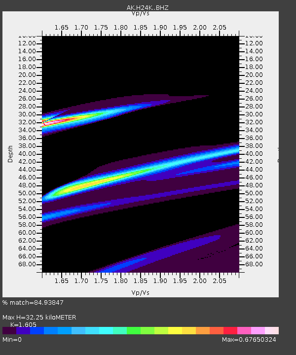
| Estimated Moho Depth: |
32.25 km |
| Estimated Crust Vp/Vs: |
1.61 |
| Assumed Crust Vp: |
6.566 km/s |
| Estimated Crust Vs: |
4.091 km/s |
| Estimated Crust Poisson's Ratio: |
0.18 |
|
| Radial Match: |
84.93847 % |
| Radial Bump: |
365 |
| Transverse Match: |
88.13364 % |
| Transverse Bump: |
189 |
| SOD ConfigId: |
23341671 |
| Insert Time: |
2021-03-18 21:44:07.149 +0000 |
| GWidth: |
2.5 |
| Max Bumps: |
400 |
| Tol: |
0.001 |
|

Signal To Noise
| Channel | StoN | STA | LTA |
| AK:H24K: :BHZ:20210304T20:33:44.439989Z | 0.6713656 | 2.4730509E-5 | 3.6836125E-5 |
| AK:H24K: :BHN:20210304T20:33:44.439989Z | 2.1769435 | 5.1564683E-5 | 2.3686734E-5 |
| AK:H24K: :BHE:20210304T20:33:44.439989Z | 0.8873548 | 3.1807456E-5 | 3.5845256E-5 |
| Arrivals |
| Ps | 3.0 SECOND |
| PpPs | 13 SECOND |
| PsPs/PpSs | 16 SECOND |


