You are here: Home > Network List > AV - Alaska Volcano Observatory Stations List
> Station AKRB Akutan Reef Bight, Akutan Volcano, Alaska > Earthquake Result Viewer
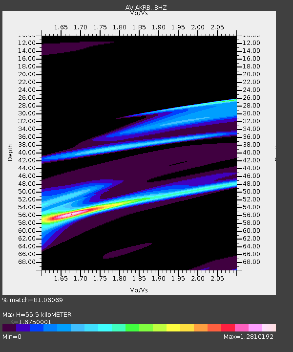
AKRB Akutan Reef Bight, Akutan Volcano, Alaska - Earthquake Result Viewer
| Earthquake location: |
Kermadec Islands Region |
| Earthquake latitude/longitude: |
-29.1/-176.7 |
| Earthquake time(UTC): |
2021/03/04 (063) 20:20:43 GMT |
| Earthquake Depth: |
10 km |
| Earthquake Magnitude: |
5.5 mb |
| Earthquake Catalog/Contributor: |
NEIC PDE/us |
|
| Network: |
AV Alaska Volcano Observatory |
| Station: |
AKRB Akutan Reef Bight, Akutan Volcano, Alaska |
| Lat/Lon: |
54.13 N/166.07 W |
| Elevation: |
334 m |
|
| Distance: |
83.3 deg |
| Az: |
6.278 deg |
| Baz: |
189.363 deg |
| Ray Param: |
0.046258394 |
| Estimated Moho Depth: |
55.5 km |
| Estimated Crust Vp/Vs: |
1.68 |
| Assumed Crust Vp: |
5.989 km/s |
| Estimated Crust Vs: |
3.576 km/s |
| Estimated Crust Poisson's Ratio: |
0.22 |
|
| Radial Match: |
81.06069 % |
| Radial Bump: |
400 |
| Transverse Match: |
80.520454 % |
| Transverse Bump: |
286 |
| SOD ConfigId: |
23341671 |
| Insert Time: |
2021-03-18 21:45:41.819 +0000 |
| GWidth: |
2.5 |
| Max Bumps: |
400 |
| Tol: |
0.001 |
|

Signal To Noise
| Channel | StoN | STA | LTA |
| AV:AKRB: :BHZ:20210304T20:32:39.340013Z | 0.77489305 | 1.2157008E-5 | 1.5688629E-5 |
| AV:AKRB: :BHN:20210304T20:32:39.340013Z | 1.0907224 | 1.5406806E-5 | 1.4125322E-5 |
| AV:AKRB: :BHE:20210304T20:32:39.340013Z | 3.1138263 | 2.4155748E-5 | 7.757577E-6 |
| Arrivals |
| Ps | 6.4 SECOND |
| PpPs | 24 SECOND |
| PsPs/PpSs | 31 SECOND |


