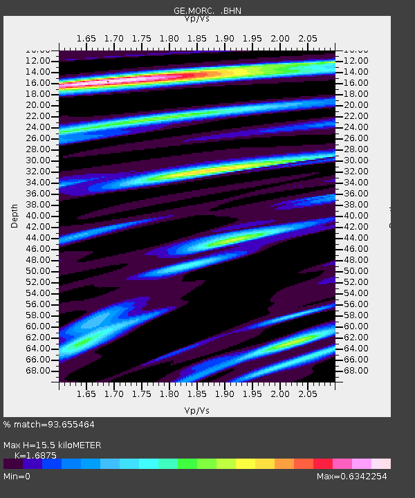
MORC GEOFON Station Moravsky Beroun, Czech Republic - Earthquake Result Viewer

Earthquake location: Near East Coast Of Honshu, Japan
Earthquake latitude/longitude: 38.1/142.1
Earthquake time(UTC): 2005/12/02 (336) 13:13:09 GMT
Earthquake Depth: 29 km
Earthquake Magnitude: 6.1 MB, 6.3 MS, 6.5 MW, 6.4 MW
Earthquake Catalog/Contributor: WHDF/NEIC
Network: GE GEOFON
Station: MORC GEOFON Station Moravsky Beroun, Czech Republic
Lat/Lon: 49.78 N/17.54 E
Elevation: 740 m
Distance: 79.8 deg
Az: 327.155 deg
Baz: 41.31 deg
Ray Param: 0.04868881
Estimated Moho Depth: 15.5 km
Estimated Crust Vp/Vs: 1.69
Assumed Crust Vp: 6.276 km/s
Estimated Crust Vs: 3.719 km/s
Estimated Crust Poisson's Ratio: 0.23
Radial Match: 93.655464 %
Radial Bump: 258
Transverse Match: 85.592384 %
Transverse Bump: 360
SOD ConfigId: 2422
Insert Time: 2010-03-09 06:01:24.885 +0000
GWidth: 2.5
Max Bumps: 400
Tol: 0.001

Signal To Noise

ChannelStoNSTALTA
GE:MORC: :BHN:20051202T13:24:43.735027Z8.431091.2213367E-61.4486106E-7
GE:MORC: :BHE:20051202T13:24:43.735027Z4.9919391.2655702E-62.5352276E-7
GE:MORC: :BHZ:20051202T13:24:43.735027Z23.744034.0930863E-61.7238379E-7
Arrivals
Ps1.7 SECOND
PpPs6.5 SECOND
PsPs/PpSs8.2 SECOND