You are here: Home > Network List > TA - USArray Transportable Network (new EarthScope stations) Stations List
> Station G21K Allakaket, AK, USA > Earthquake Result Viewer
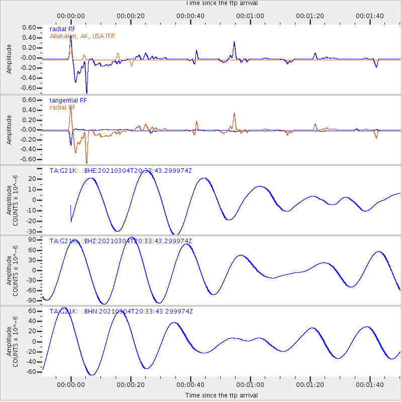
G21K Allakaket, AK, USA - Earthquake Result Viewer
*The percent match for this event was below the threshold and hence no stack was calculated.
| Earthquake location: |
Kermadec Islands Region |
| Earthquake latitude/longitude: |
-29.1/-176.7 |
| Earthquake time(UTC): |
2021/03/04 (063) 20:20:43 GMT |
| Earthquake Depth: |
10 km |
| Earthquake Magnitude: |
5.5 mb |
| Earthquake Catalog/Contributor: |
NEIC PDE/us |
|
| Network: |
TA USArray Transportable Network (new EarthScope stations) |
| Station: |
G21K Allakaket, AK, USA |
| Lat/Lon: |
66.52 N/153.51 W |
| Elevation: |
446 m |
|
| Distance: |
96.9 deg |
| Az: |
9.15 deg |
| Baz: |
200.331 deg |
| Ray Param: |
$rayparam |
*The percent match for this event was below the threshold and hence was not used in the summary stack. |
|
| Radial Match: |
89.71793 % |
| Radial Bump: |
400 |
| Transverse Match: |
72.29997 % |
| Transverse Bump: |
327 |
| SOD ConfigId: |
23341671 |
| Insert Time: |
2021-03-18 21:53:57.062 +0000 |
| GWidth: |
2.5 |
| Max Bumps: |
400 |
| Tol: |
0.001 |
|
Signal To Noise
| Channel | StoN | STA | LTA |
| TA:G21K: :BHZ:20210304T20:33:43.299974Z | 1.8091375 | 9.158469E-5 | 5.06234E-5 |
| TA:G21K: :BHN:20210304T20:33:43.299974Z | 0.7093347 | 3.788832E-5 | 5.3413885E-5 |
| TA:G21K: :BHE:20210304T20:33:43.299974Z | 1.1159487 | 2.0152645E-5 | 1.8058758E-5 |
| Arrivals |
| Ps | |
| PpPs | |
| PsPs/PpSs | |


