You are here: Home > Network List > TA - USArray Transportable Network (new EarthScope stations) Stations List
> Station L27K Beaver Creek, Northway Junction, AK, USA > Earthquake Result Viewer
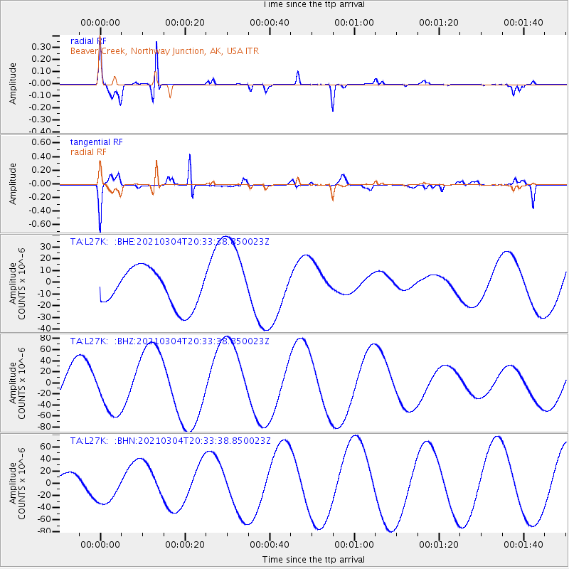
L27K Beaver Creek, Northway Junction, AK, USA - Earthquake Result Viewer
| Earthquake location: |
Kermadec Islands Region |
| Earthquake latitude/longitude: |
-29.1/-176.7 |
| Earthquake time(UTC): |
2021/03/04 (063) 20:20:43 GMT |
| Earthquake Depth: |
10 km |
| Earthquake Magnitude: |
5.5 mb |
| Earthquake Catalog/Contributor: |
NEIC PDE/us |
|
| Network: |
TA USArray Transportable Network (new EarthScope stations) |
| Station: |
L27K Beaver Creek, Northway Junction, AK, USA |
| Lat/Lon: |
63.06 N/141.83 W |
| Elevation: |
755 m |
|
| Distance: |
95.9 deg |
| Az: |
15.179 deg |
| Baz: |
210.222 deg |
| Ray Param: |
0.04066595 |
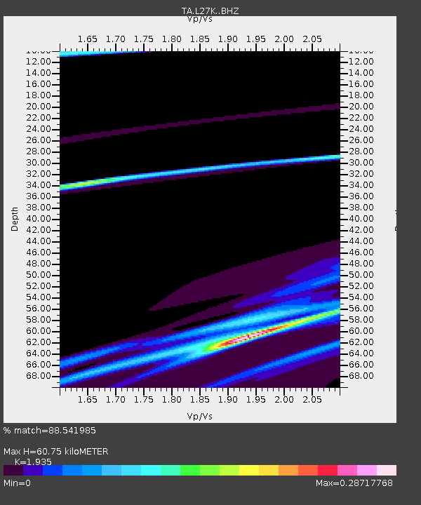
| Estimated Moho Depth: |
60.75 km |
| Estimated Crust Vp/Vs: |
1.93 |
| Assumed Crust Vp: |
6.566 km/s |
| Estimated Crust Vs: |
3.393 km/s |
| Estimated Crust Poisson's Ratio: |
0.32 |
|
| Radial Match: |
88.541985 % |
| Radial Bump: |
165 |
| Transverse Match: |
86.84587 % |
| Transverse Bump: |
398 |
| SOD ConfigId: |
23341671 |
| Insert Time: |
2021-03-18 21:54:02.685 +0000 |
| GWidth: |
2.5 |
| Max Bumps: |
400 |
| Tol: |
0.001 |
|
Signal To Noise
| Channel | StoN | STA | LTA |
| TA:L27K: :BHZ:20210304T20:33:38.850023Z | 1.2170329 | 4.575164E-5 | 3.759277E-5 |
| TA:L27K: :BHN:20210304T20:33:38.850023Z | 2.519016 | 2.6755295E-5 | 1.0621328E-5 |
| TA:L27K: :BHE:20210304T20:33:38.850023Z | 2.1741595 | 3.4436347E-5 | 1.5838925E-5 |
| Arrivals |
| Ps | 8.8 SECOND |
| PpPs | 27 SECOND |
| PsPs/PpSs | 35 SECOND |


