You are here: Home > Network List > TA - USArray Transportable Network (new EarthScope stations) Stations List
> Station L29M Grand Valley Creek, YT, CAN > Earthquake Result Viewer
L29M Grand Valley Creek, YT, CAN - Earthquake Result Viewer
| Earthquake location: |
Kermadec Islands Region |
| Earthquake latitude/longitude: |
-29.1/-176.7 |
| Earthquake time(UTC): |
2021/03/04 (063) 20:20:43 GMT |
| Earthquake Depth: |
10 km |
| Earthquake Magnitude: |
5.5 mb |
| Earthquake Catalog/Contributor: |
NEIC PDE/us |
|
| Network: |
TA USArray Transportable Network (new EarthScope stations) |
| Station: |
L29M Grand Valley Creek, YT, CAN |
| Lat/Lon: |
63.11 N/138.13 W |
| Elevation: |
918 m |
|
| Distance: |
96.8 deg |
| Az: |
16.593 deg |
| Baz: |
213.359 deg |
| Ray Param: |
0.040400375 |
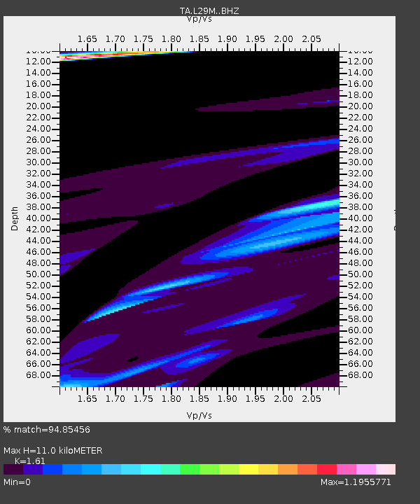
| Estimated Moho Depth: |
11.0 km |
| Estimated Crust Vp/Vs: |
1.61 |
| Assumed Crust Vp: |
6.566 km/s |
| Estimated Crust Vs: |
4.078 km/s |
| Estimated Crust Poisson's Ratio: |
0.19 |
|
| Radial Match: |
94.85456 % |
| Radial Bump: |
329 |
| Transverse Match: |
32.448708 % |
| Transverse Bump: |
329 |
| SOD ConfigId: |
23341671 |
| Insert Time: |
2021-03-18 21:54:03.179 +0000 |
| GWidth: |
2.5 |
| Max Bumps: |
400 |
| Tol: |
0.001 |
|
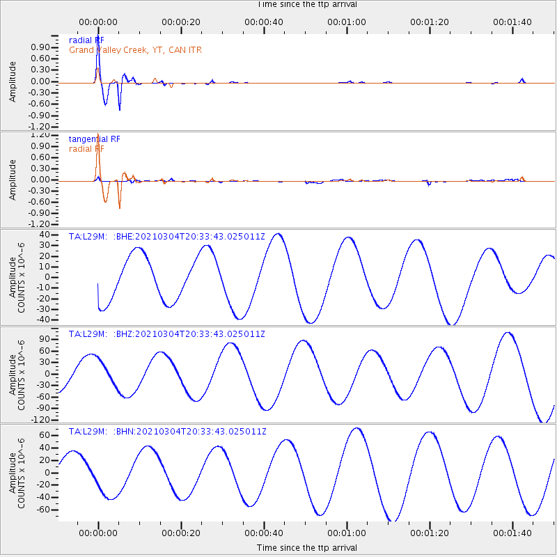
Signal To Noise
| Channel | StoN | STA | LTA |
| TA:L29M: :BHZ:20210304T20:33:43.025011Z | 1.2083656 | 3.506154E-5 | 2.9015673E-5 |
| TA:L29M: :BHN:20210304T20:33:43.025011Z | 1.7799898 | 3.613443E-5 | 2.0300356E-5 |
| TA:L29M: :BHE:20210304T20:33:43.025011Z | 1.2753514 | 2.5639714E-5 | 2.0104038E-5 |
| Arrivals |
| Ps | 1.0 SECOND |
| PpPs | 4.3 SECOND |
| PsPs/PpSs | 5.3 SECOND |


