You are here: Home > Network List > UW - Pacific Northwest Regional Seismic Network Stations List
> Station HOOD Mt Hood Meadows, OR CREST BB SMO > Earthquake Result Viewer
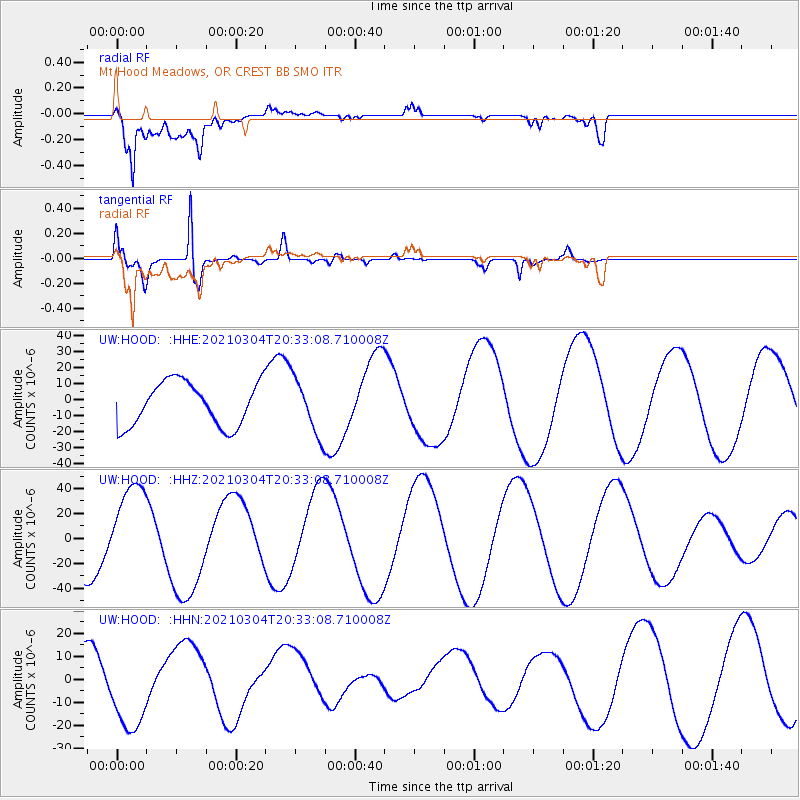
HOOD Mt Hood Meadows, OR CREST BB SMO - Earthquake Result Viewer
*The percent match for this event was below the threshold and hence no stack was calculated.
| Earthquake location: |
Kermadec Islands Region |
| Earthquake latitude/longitude: |
-29.1/-176.7 |
| Earthquake time(UTC): |
2021/03/04 (063) 20:20:43 GMT |
| Earthquake Depth: |
10 km |
| Earthquake Magnitude: |
5.5 mb |
| Earthquake Catalog/Contributor: |
NEIC PDE/us |
|
| Network: |
UW Pacific Northwest Regional Seismic Network |
| Station: |
HOOD Mt Hood Meadows, OR CREST BB SMO |
| Lat/Lon: |
45.32 N/121.65 W |
| Elevation: |
1520 m |
|
| Distance: |
89.3 deg |
| Az: |
35.333 deg |
| Baz: |
225.868 deg |
| Ray Param: |
$rayparam |
*The percent match for this event was below the threshold and hence was not used in the summary stack. |
|
| Radial Match: |
61.513813 % |
| Radial Bump: |
400 |
| Transverse Match: |
96.56731 % |
| Transverse Bump: |
323 |
| SOD ConfigId: |
23341671 |
| Insert Time: |
2021-03-18 21:56:16.539 +0000 |
| GWidth: |
2.5 |
| Max Bumps: |
400 |
| Tol: |
0.001 |
|
Signal To Noise
| Channel | StoN | STA | LTA |
| UW:HOOD: :HHZ:20210304T20:33:08.710008Z | 1.73166 | 3.538818E-5 | 2.0435988E-5 |
| UW:HOOD: :HHN:20210304T20:33:08.710008Z | 2.4422238 | 1.8435367E-5 | 7.5485987E-6 |
| UW:HOOD: :HHE:20210304T20:33:08.710008Z | 1.2803799 | 1.7535676E-5 | 1.3695682E-5 |
| Arrivals |
| Ps | |
| PpPs | |
| PsPs/PpSs | |


