You are here: Home > Network List > TA - USArray Transportable Network (new EarthScope stations) Stations List
> Station E20K Nigu River, AK, USA > Earthquake Result Viewer
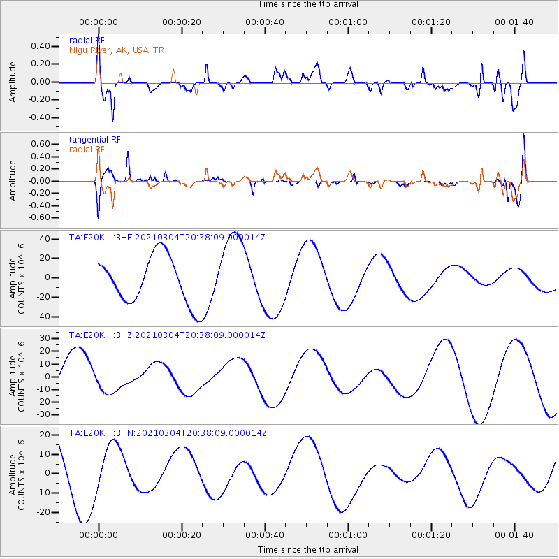
E20K Nigu River, AK, USA - Earthquake Result Viewer
*The percent match for this event was below the threshold and hence no stack was calculated.
| Earthquake location: |
Kermadec Islands Region |
| Earthquake latitude/longitude: |
-28.4/-176.6 |
| Earthquake time(UTC): |
2021/03/04 (063) 20:25:06 GMT |
| Earthquake Depth: |
10 km |
| Earthquake Magnitude: |
6.1 mb |
| Earthquake Catalog/Contributor: |
NEIC PDE/us |
|
| Network: |
TA USArray Transportable Network (new EarthScope stations) |
| Station: |
E20K Nigu River, AK, USA |
| Lat/Lon: |
68.26 N/156.19 W |
| Elevation: |
866 m |
|
| Distance: |
97.6 deg |
| Az: |
7.548 deg |
| Baz: |
198.096 deg |
| Ray Param: |
$rayparam |
*The percent match for this event was below the threshold and hence was not used in the summary stack. |
|
| Radial Match: |
56.291763 % |
| Radial Bump: |
400 |
| Transverse Match: |
68.13703 % |
| Transverse Bump: |
386 |
| SOD ConfigId: |
23341671 |
| Insert Time: |
2021-03-18 22:08:03.549 +0000 |
| GWidth: |
2.5 |
| Max Bumps: |
400 |
| Tol: |
0.001 |
|
Signal To Noise
| Channel | StoN | STA | LTA |
| TA:E20K: :BHZ:20210304T20:38:09.000014Z | 0.47439367 | 1.08363465E-5 | 2.284252E-5 |
| TA:E20K: :BHN:20210304T20:38:09.000014Z | 0.46129134 | 1.1399107E-5 | 2.4711298E-5 |
| TA:E20K: :BHE:20210304T20:38:09.000014Z | 1.7398846 | 4.168506E-5 | 2.395852E-5 |
| Arrivals |
| Ps | |
| PpPs | |
| PsPs/PpSs | |


