You are here: Home > Network List > TA - USArray Transportable Network (new EarthScope stations) Stations List
> Station H19K Roundabout Mountain, AK, USA > Earthquake Result Viewer
H19K Roundabout Mountain, AK, USA - Earthquake Result Viewer
| Earthquake location: |
Kermadec Islands Region |
| Earthquake latitude/longitude: |
-28.4/-176.6 |
| Earthquake time(UTC): |
2021/03/04 (063) 20:25:06 GMT |
| Earthquake Depth: |
10 km |
| Earthquake Magnitude: |
6.1 mb |
| Earthquake Catalog/Contributor: |
NEIC PDE/us |
|
| Network: |
TA USArray Transportable Network (new EarthScope stations) |
| Station: |
H19K Roundabout Mountain, AK, USA |
| Lat/Lon: |
65.53 N/156.45 W |
| Elevation: |
107 m |
|
| Distance: |
94.9 deg |
| Az: |
8.299 deg |
| Baz: |
197.775 deg |
| Ray Param: |
0.04092861 |
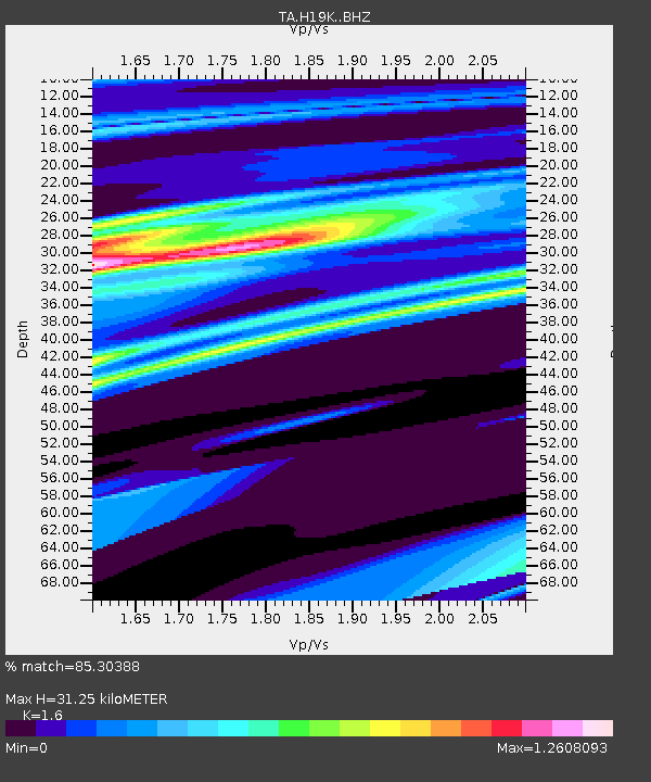
| Estimated Moho Depth: |
31.25 km |
| Estimated Crust Vp/Vs: |
1.60 |
| Assumed Crust Vp: |
6.182 km/s |
| Estimated Crust Vs: |
3.864 km/s |
| Estimated Crust Poisson's Ratio: |
0.18 |
|
| Radial Match: |
85.30388 % |
| Radial Bump: |
400 |
| Transverse Match: |
96.37299 % |
| Transverse Bump: |
326 |
| SOD ConfigId: |
23341671 |
| Insert Time: |
2021-03-18 22:08:09.287 +0000 |
| GWidth: |
2.5 |
| Max Bumps: |
400 |
| Tol: |
0.001 |
|

Signal To Noise
| Channel | StoN | STA | LTA |
| TA:H19K: :BHZ:20210304T20:37:57.09999Z | 1.851338 | 3.6512833E-5 | 1.9722404E-5 |
| TA:H19K: :BHN:20210304T20:37:57.09999Z | 0.8087347 | 2.3706441E-5 | 2.9313002E-5 |
| TA:H19K: :BHE:20210304T20:37:57.09999Z | 3.1698408 | 1.2302687E-5 | 3.8811686E-6 |
| Arrivals |
| Ps | 3.1 SECOND |
| PpPs | 13 SECOND |
| PsPs/PpSs | 16 SECOND |


