You are here: Home > Network List > TA - USArray Transportable Network (new EarthScope stations) Stations List
> Station M31M Drury Creek, Yukon, CA > Earthquake Result Viewer
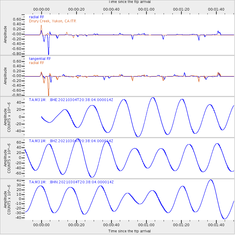
M31M Drury Creek, Yukon, CA - Earthquake Result Viewer
*The percent match for this event was below the threshold and hence no stack was calculated.
| Earthquake location: |
Kermadec Islands Region |
| Earthquake latitude/longitude: |
-28.4/-176.6 |
| Earthquake time(UTC): |
2021/03/04 (063) 20:25:06 GMT |
| Earthquake Depth: |
10 km |
| Earthquake Magnitude: |
6.1 mb |
| Earthquake Catalog/Contributor: |
NEIC PDE/us |
|
| Network: |
TA USArray Transportable Network (new EarthScope stations) |
| Station: |
M31M Drury Creek, Yukon, CA |
| Lat/Lon: |
62.20 N/134.39 W |
| Elevation: |
639 m |
|
| Distance: |
96.4 deg |
| Az: |
18.496 deg |
| Baz: |
216.597 deg |
| Ray Param: |
$rayparam |
*The percent match for this event was below the threshold and hence was not used in the summary stack. |
|
| Radial Match: |
90.39157 % |
| Radial Bump: |
238 |
| Transverse Match: |
83.22891 % |
| Transverse Bump: |
308 |
| SOD ConfigId: |
23341671 |
| Insert Time: |
2021-03-18 22:08:18.586 +0000 |
| GWidth: |
2.5 |
| Max Bumps: |
400 |
| Tol: |
0.001 |
|
Signal To Noise
| Channel | StoN | STA | LTA |
| TA:M31M: :BHZ:20210304T20:38:04.000014Z | 0.89786184 | 3.3865006E-5 | 3.771739E-5 |
| TA:M31M: :BHN:20210304T20:38:04.000014Z | 1.3663456 | 2.3926188E-5 | 1.7511082E-5 |
| TA:M31M: :BHE:20210304T20:38:04.000014Z | 1.6986167 | 2.5037893E-5 | 1.4740166E-5 |
| Arrivals |
| Ps | |
| PpPs | |
| PsPs/PpSs | |


