You are here: Home > Network List > TA - USArray Transportable Network (new EarthScope stations) Stations List
> Station O28M Mount Upton, YT, CAN > Earthquake Result Viewer
O28M Mount Upton, YT, CAN - Earthquake Result Viewer
| Earthquake location: |
Kermadec Islands Region |
| Earthquake latitude/longitude: |
-28.4/-176.6 |
| Earthquake time(UTC): |
2021/03/04 (063) 20:25:06 GMT |
| Earthquake Depth: |
10 km |
| Earthquake Magnitude: |
6.1 mb |
| Earthquake Catalog/Contributor: |
NEIC PDE/us |
|
| Network: |
TA USArray Transportable Network (new EarthScope stations) |
| Station: |
O28M Mount Upton, YT, CAN |
| Lat/Lon: |
60.77 N/140.19 W |
| Elevation: |
2622 m |
|
| Distance: |
93.7 deg |
| Az: |
16.991 deg |
| Baz: |
211.64 deg |
| Ray Param: |
0.041213695 |
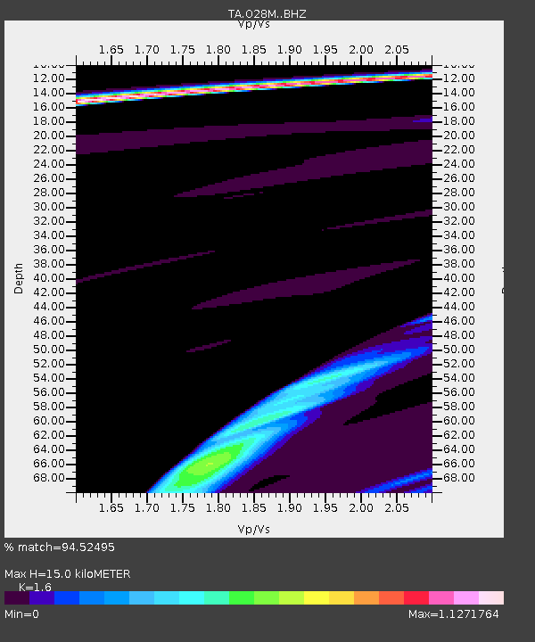
| Estimated Moho Depth: |
15.0 km |
| Estimated Crust Vp/Vs: |
1.60 |
| Assumed Crust Vp: |
6.566 km/s |
| Estimated Crust Vs: |
4.104 km/s |
| Estimated Crust Poisson's Ratio: |
0.18 |
|
| Radial Match: |
94.52495 % |
| Radial Bump: |
244 |
| Transverse Match: |
93.0045 % |
| Transverse Bump: |
255 |
| SOD ConfigId: |
23341671 |
| Insert Time: |
2021-03-18 22:08:23.251 +0000 |
| GWidth: |
2.5 |
| Max Bumps: |
400 |
| Tol: |
0.001 |
|

Signal To Noise
| Channel | StoN | STA | LTA |
| TA:O28M: :BHZ:20210304T20:37:51.550002Z | 1.0272613 | 3.492151E-5 | 3.3994773E-5 |
| TA:O28M: :BHN:20210304T20:37:51.550002Z | 0.89159566 | 1.8064891E-5 | 2.0261305E-5 |
| TA:O28M: :BHE:20210304T20:37:51.550002Z | 1.9398113 | 3.9939816E-5 | 2.0589536E-5 |
| Arrivals |
| Ps | 1.4 SECOND |
| PpPs | 5.8 SECOND |
| PsPs/PpSs | 7.2 SECOND |


