You are here: Home > Network List > UW - Pacific Northwest Regional Seismic Network Stations List
> Station YACT Amboy, WA, USA > Earthquake Result Viewer
YACT Amboy, WA, USA - Earthquake Result Viewer
| Earthquake location: |
Kermadec Islands Region |
| Earthquake latitude/longitude: |
-28.4/-176.6 |
| Earthquake time(UTC): |
2021/03/04 (063) 20:25:06 GMT |
| Earthquake Depth: |
10 km |
| Earthquake Magnitude: |
6.1 mb |
| Earthquake Catalog/Contributor: |
NEIC PDE/us |
|
| Network: |
UW Pacific Northwest Regional Seismic Network |
| Station: |
YACT Amboy, WA, USA |
| Lat/Lon: |
45.93 N/122.42 W |
| Elevation: |
211 m |
|
| Distance: |
88.8 deg |
| Az: |
34.497 deg |
| Baz: |
225.639 deg |
| Ray Param: |
0.042303767 |
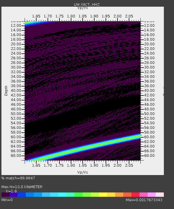
| Estimated Moho Depth: |
10.0 km |
| Estimated Crust Vp/Vs: |
1.60 |
| Assumed Crust Vp: |
6.566 km/s |
| Estimated Crust Vs: |
4.104 km/s |
| Estimated Crust Poisson's Ratio: |
0.18 |
|
| Radial Match: |
99.9947 % |
| Radial Bump: |
2 |
| Transverse Match: |
99.9947 % |
| Transverse Bump: |
2 |
| SOD ConfigId: |
23341671 |
| Insert Time: |
2021-03-18 22:10:53.819 +0000 |
| GWidth: |
2.5 |
| Max Bumps: |
400 |
| Tol: |
0.001 |
|
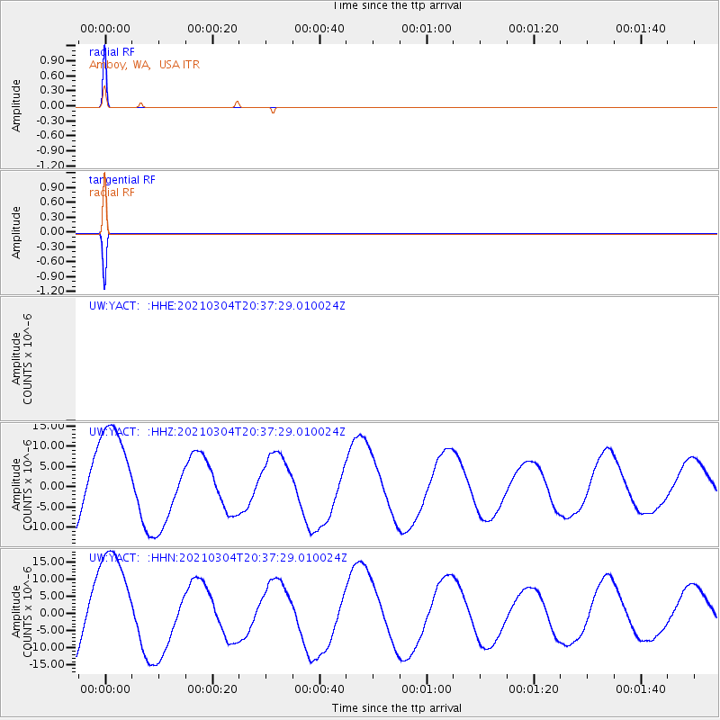
Signal To Noise
| Channel | StoN | STA | LTA |
| UW:YACT: :HHZ:20210304T20:37:29.010024Z | 1.9205983 | 1.3842806E-5 | 7.207549E-6 |
| UW:YACT: :HHN:20210304T20:37:29.010024Z | 1.9244688 | 1.6565016E-5 | 8.607579E-6 |
| $trig.getChannelId() | $trig.getValue() | $trig.getSTA() | $trig.getLTA() |
| Arrivals |
| Ps | 0.9 SECOND |
| PpPs | 3.9 SECOND |
| PsPs/PpSs | 4.8 SECOND |


