You are here: Home > Network List > MB - Montana Regional Seismic Network Stations List
> Station BUT Butte, Montana > Earthquake Result Viewer
BUT Butte, Montana - Earthquake Result Viewer
| Earthquake location: |
Kermadec Islands, New Zealand |
| Earthquake latitude/longitude: |
-29.4/-177.1 |
| Earthquake time(UTC): |
2021/03/04 (063) 21:04:06 GMT |
| Earthquake Depth: |
10 km |
| Earthquake Magnitude: |
5.8 mb |
| Earthquake Catalog/Contributor: |
NEIC PDE/us |
|
| Network: |
MB Montana Regional Seismic Network |
| Station: |
BUT Butte, Montana |
| Lat/Lon: |
46.01 N/112.56 W |
| Elevation: |
1758 m |
|
| Distance: |
95.1 deg |
| Az: |
39.186 deg |
| Baz: |
232.285 deg |
| Ray Param: |
0.040879067 |
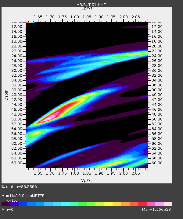
| Estimated Moho Depth: |
10.0 km |
| Estimated Crust Vp/Vs: |
1.60 |
| Assumed Crust Vp: |
6.353 km/s |
| Estimated Crust Vs: |
3.971 km/s |
| Estimated Crust Poisson's Ratio: |
0.18 |
|
| Radial Match: |
86.5895 % |
| Radial Bump: |
400 |
| Transverse Match: |
77.15617 % |
| Transverse Bump: |
400 |
| SOD ConfigId: |
23341671 |
| Insert Time: |
2021-03-18 22:27:40.797 +0000 |
| GWidth: |
2.5 |
| Max Bumps: |
400 |
| Tol: |
0.001 |
|

Signal To Noise
| Channel | StoN | STA | LTA |
| MB:BUT:01:HHZ:20210304T21:16:57.649985Z | 2.5944657 | 5.076245E-5 | 1.9565665E-5 |
| MB:BUT:01:HHN:20210304T21:16:57.649985Z | 1.1724715 | 1.9367795E-5 | 1.6518778E-5 |
| MB:BUT:01:HHE:20210304T21:16:57.649985Z | 0.6743409 | 1.526727E-5 | 2.2640284E-5 |
| Arrivals |
| Ps | 1.0 SECOND |
| PpPs | 4.0 SECOND |
| PsPs/PpSs | 5.0 SECOND |


