You are here: Home > Network List > O2 - Oklahoma Consolidated Temporary Seismic Networks Stations List
> Station FW01 Cuddy Creek, Oklahoma, USA > Earthquake Result Viewer
FW01 Cuddy Creek, Oklahoma, USA - Earthquake Result Viewer
| Earthquake location: |
Kermadec Islands, New Zealand |
| Earthquake latitude/longitude: |
-29.4/-177.1 |
| Earthquake time(UTC): |
2021/03/04 (063) 21:04:06 GMT |
| Earthquake Depth: |
10 km |
| Earthquake Magnitude: |
5.8 mb |
| Earthquake Catalog/Contributor: |
NEIC PDE/us |
|
| Network: |
O2 Oklahoma Consolidated Temporary Seismic Networks |
| Station: |
FW01 Cuddy Creek, Oklahoma, USA |
| Lat/Lon: |
36.49 N/98.94 W |
| Elevation: |
431 m |
|
| Distance: |
98.3 deg |
| Az: |
52.858 deg |
| Baz: |
239.674 deg |
| Ray Param: |
0.039931115 |
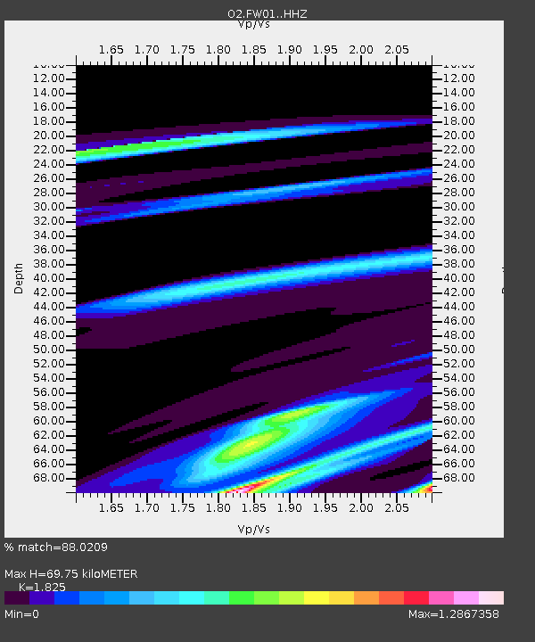
| Estimated Moho Depth: |
69.75 km |
| Estimated Crust Vp/Vs: |
1.83 |
| Assumed Crust Vp: |
6.426 km/s |
| Estimated Crust Vs: |
3.521 km/s |
| Estimated Crust Poisson's Ratio: |
0.29 |
|
| Radial Match: |
88.0209 % |
| Radial Bump: |
369 |
| Transverse Match: |
71.65945 % |
| Transverse Bump: |
400 |
| SOD ConfigId: |
23341671 |
| Insert Time: |
2021-03-18 22:28:45.051 +0000 |
| GWidth: |
2.5 |
| Max Bumps: |
400 |
| Tol: |
0.001 |
|

Signal To Noise
| Channel | StoN | STA | LTA |
| O2:FW01: :HHZ:20210304T21:17:12.165Z | 2.091741 | 1.8457798E-5 | 8.824131E-6 |
| O2:FW01: :HHN:20210304T21:17:12.165Z | 0.6438255 | 5.734987E-6 | 8.907673E-6 |
| O2:FW01: :HHE:20210304T21:17:12.165Z | 1.4998745 | 1.33799385E-5 | 8.920706E-6 |
| Arrivals |
| Ps | 9.1 SECOND |
| PpPs | 30 SECOND |
| PsPs/PpSs | 39 SECOND |


