You are here: Home > Network List > TX - Texas Seismological Network Stations List
> Station DRZT Darrouzett > Earthquake Result Viewer
DRZT Darrouzett - Earthquake Result Viewer
| Earthquake location: |
Kermadec Islands, New Zealand |
| Earthquake latitude/longitude: |
-29.4/-177.1 |
| Earthquake time(UTC): |
2021/03/04 (063) 21:04:06 GMT |
| Earthquake Depth: |
10 km |
| Earthquake Magnitude: |
5.8 mb |
| Earthquake Catalog/Contributor: |
NEIC PDE/us |
|
| Network: |
TX Texas Seismological Network |
| Station: |
DRZT Darrouzett |
| Lat/Lon: |
36.44 N/100.30 W |
| Elevation: |
791 m |
|
| Distance: |
97.4 deg |
| Az: |
52.339 deg |
| Baz: |
238.943 deg |
| Ray Param: |
0.040235873 |
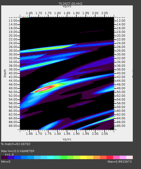
| Estimated Moho Depth: |
10.0 km |
| Estimated Crust Vp/Vs: |
1.60 |
| Assumed Crust Vp: |
6.483 km/s |
| Estimated Crust Vs: |
4.052 km/s |
| Estimated Crust Poisson's Ratio: |
0.18 |
|
| Radial Match: |
92.08782 % |
| Radial Bump: |
400 |
| Transverse Match: |
56.92068 % |
| Transverse Bump: |
392 |
| SOD ConfigId: |
23341671 |
| Insert Time: |
2021-03-18 22:31:18.327 +0000 |
| GWidth: |
2.5 |
| Max Bumps: |
400 |
| Tol: |
0.001 |
|

Signal To Noise
| Channel | StoN | STA | LTA |
| TX:DRZT:00:HHZ:20210304T21:17:07.865012Z | 1.1066872 | 1.1407795E-5 | 1.0308057E-5 |
| TX:DRZT:00:HH1:20210304T21:17:07.865012Z | 2.4049196 | 2.0983318E-5 | 8.725163E-6 |
| TX:DRZT:00:HH2:20210304T21:17:07.865012Z | 1.3669841 | 9.142233E-6 | 6.6878847E-6 |
| Arrivals |
| Ps | 0.9 SECOND |
| PpPs | 3.9 SECOND |
| PsPs/PpSs | 4.9 SECOND |


