You are here: Home > Network List > AV - Alaska Volcano Observatory Stations List
> Station MAPS Pakushin Southeast, Makushin Volcano, Alaska > Earthquake Result Viewer
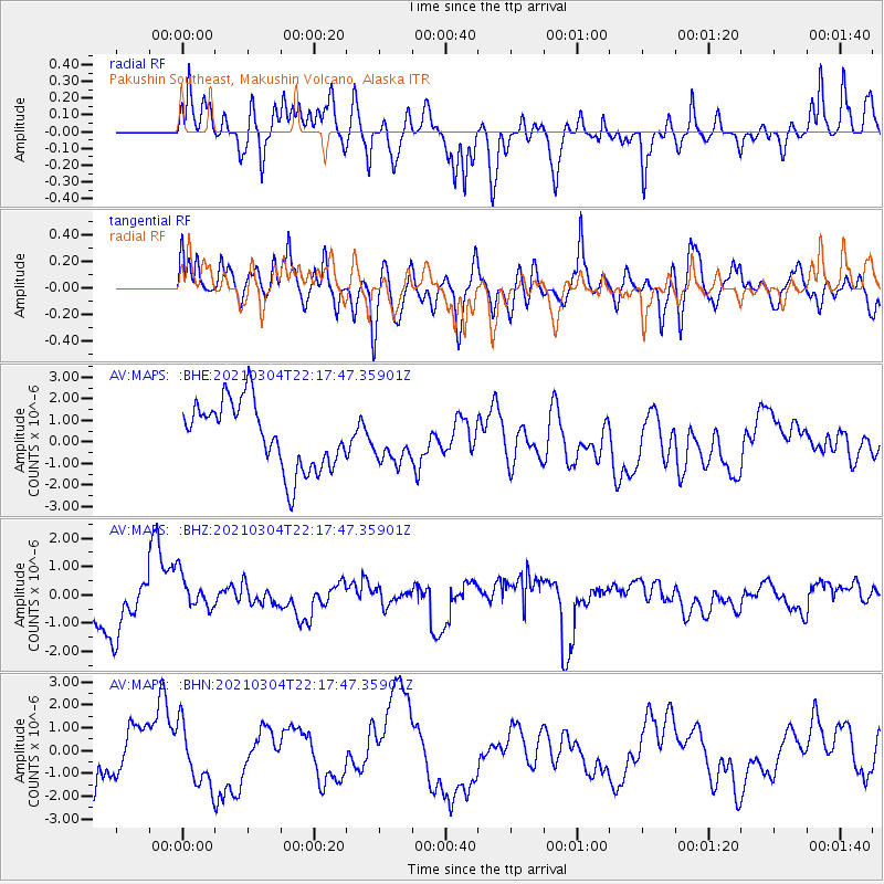
MAPS Pakushin Southeast, Makushin Volcano, Alaska - Earthquake Result Viewer
*The percent match for this event was below the threshold and hence no stack was calculated.
| Earthquake location: |
Kermadec Islands Region |
| Earthquake latitude/longitude: |
-28.6/-176.7 |
| Earthquake time(UTC): |
2021/03/04 (063) 22:05:56 GMT |
| Earthquake Depth: |
10 km |
| Earthquake Magnitude: |
5.5 mb |
| Earthquake Catalog/Contributor: |
NEIC PDE/us |
|
| Network: |
AV Alaska Volcano Observatory |
| Station: |
MAPS Pakushin Southeast, Makushin Volcano, Alaska |
| Lat/Lon: |
53.81 N/166.94 W |
| Elevation: |
333 m |
|
| Distance: |
82.5 deg |
| Az: |
5.798 deg |
| Baz: |
188.616 deg |
| Ray Param: |
$rayparam |
*The percent match for this event was below the threshold and hence was not used in the summary stack. |
|
| Radial Match: |
41.91102 % |
| Radial Bump: |
400 |
| Transverse Match: |
46.18344 % |
| Transverse Bump: |
400 |
| SOD ConfigId: |
23341671 |
| Insert Time: |
2021-03-18 23:09:58.807 +0000 |
| GWidth: |
2.5 |
| Max Bumps: |
400 |
| Tol: |
0.001 |
|
Signal To Noise
| Channel | StoN | STA | LTA |
| AV:MAPS: :BHZ:20210304T22:17:47.35901Z | 0.81615293 | 6.449353E-7 | 7.9021385E-7 |
| AV:MAPS: :BHN:20210304T22:17:47.35901Z | 0.9123478 | 1.3464006E-6 | 1.4757537E-6 |
| AV:MAPS: :BHE:20210304T22:17:47.35901Z | 0.6402388 | 9.811457E-7 | 1.5324682E-6 |
| Arrivals |
| Ps | |
| PpPs | |
| PsPs/PpSs | |


