You are here: Home > Network List > TA - USArray Transportable Network (new EarthScope stations) Stations List
> Station G16K Koyuk River, AK, USA > Earthquake Result Viewer
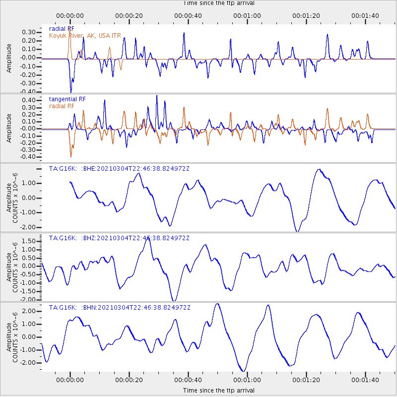
G16K Koyuk River, AK, USA - Earthquake Result Viewer
*The percent match for this event was below the threshold and hence no stack was calculated.
| Earthquake location: |
Kermadec Islands, New Zealand |
| Earthquake latitude/longitude: |
-29.9/-177.1 |
| Earthquake time(UTC): |
2021/03/04 (063) 22:33:44 GMT |
| Earthquake Depth: |
10 km |
| Earthquake Magnitude: |
5.8 mb |
| Earthquake Catalog/Contributor: |
NEIC PDE/us |
|
| Network: |
TA USArray Transportable Network (new EarthScope stations) |
| Station: |
G16K Koyuk River, AK, USA |
| Lat/Lon: |
65.39 N/162.35 W |
| Elevation: |
169 m |
|
| Distance: |
95.7 deg |
| Az: |
6.145 deg |
| Baz: |
192.821 deg |
| Ray Param: |
$rayparam |
*The percent match for this event was below the threshold and hence was not used in the summary stack. |
|
| Radial Match: |
71.40816 % |
| Radial Bump: |
249 |
| Transverse Match: |
70.999115 % |
| Transverse Bump: |
203 |
| SOD ConfigId: |
23341671 |
| Insert Time: |
2021-03-18 23:46:24.468 +0000 |
| GWidth: |
2.5 |
| Max Bumps: |
400 |
| Tol: |
0.001 |
|
Signal To Noise
| Channel | StoN | STA | LTA |
| TA:G16K: :BHZ:20210304T22:46:38.824972Z | 0.75335425 | 4.4128868E-7 | 5.857652E-7 |
| TA:G16K: :BHN:20210304T22:46:38.824972Z | 1.8830036 | 1.6552699E-6 | 8.7905823E-7 |
| TA:G16K: :BHE:20210304T22:46:38.824972Z | 2.387736 | 1.6932136E-6 | 7.0912927E-7 |
| Arrivals |
| Ps | |
| PpPs | |
| PsPs/PpSs | |


