You are here: Home > Network List > AV - Alaska Volcano Observatory Stations List
> Station SPCR Ckakachatna River, Mount Spurr, Alaska > Earthquake Result Viewer
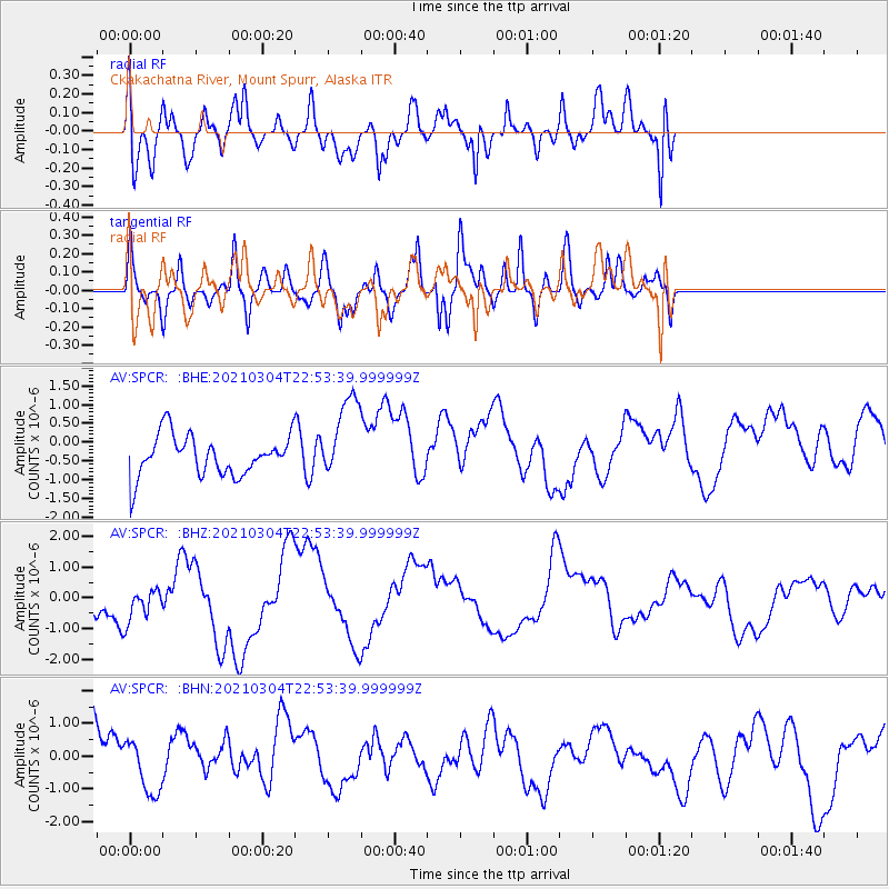
SPCR Ckakachatna River, Mount Spurr, Alaska - Earthquake Result Viewer
*The percent match for this event was below the threshold and hence no stack was calculated.
| Earthquake location: |
Kermadec Islands Region |
| Earthquake latitude/longitude: |
-28.4/-176.6 |
| Earthquake time(UTC): |
2021/03/04 (063) 22:41:05 GMT |
| Earthquake Depth: |
10 km |
| Earthquake Magnitude: |
5.8 mb |
| Earthquake Catalog/Contributor: |
NEIC PDE/us |
|
| Network: |
AV Alaska Volcano Observatory |
| Station: |
SPCR Ckakachatna River, Mount Spurr, Alaska |
| Lat/Lon: |
61.20 N/152.21 W |
| Elevation: |
984 m |
|
| Distance: |
91.4 deg |
| Az: |
11.538 deg |
| Baz: |
201.348 deg |
| Ray Param: |
$rayparam |
*The percent match for this event was below the threshold and hence was not used in the summary stack. |
|
| Radial Match: |
59.37218 % |
| Radial Bump: |
400 |
| Transverse Match: |
51.026844 % |
| Transverse Bump: |
400 |
| SOD ConfigId: |
23341671 |
| Insert Time: |
2021-03-18 23:53:10.202 +0000 |
| GWidth: |
2.5 |
| Max Bumps: |
400 |
| Tol: |
0.001 |
|
Signal To Noise
| Channel | StoN | STA | LTA |
| AV:SPCR: :BHZ:20210304T22:53:39.999999Z | 0.8849564 | 5.862918E-7 | 6.625092E-7 |
| AV:SPCR: :BHN:20210304T22:53:39.999999Z | 0.78211486 | 8.073336E-7 | 1.0322443E-6 |
| AV:SPCR: :BHE:20210304T22:53:39.999999Z | 2.0691805 | 1.1311809E-6 | 5.4668055E-7 |
| Arrivals |
| Ps | |
| PpPs | |
| PsPs/PpSs | |


