You are here: Home > Network List > GS - US Geological Survey Networks Stations List
> Station KAN10 Keim Farm > Earthquake Result Viewer
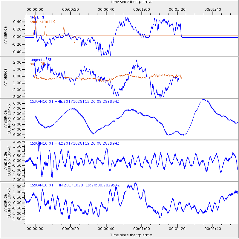
KAN10 Keim Farm - Earthquake Result Viewer
*The percent match for this event was below the threshold and hence no stack was calculated.
| Earthquake location: |
North Of Franz Josef Land |
| Earthquake latitude/longitude: |
86.9/55.1 |
| Earthquake time(UTC): |
2017/10/28 (301) 19:11:01 GMT |
| Earthquake Depth: |
10 km |
| Earthquake Magnitude: |
6.0 Mww |
| Earthquake Catalog/Contributor: |
NEIC PDE/us |
|
| Network: |
GS US Geological Survey Networks |
| Station: |
KAN10 Keim Farm |
| Lat/Lon: |
37.12 N/98.10 W |
| Elevation: |
417 m |
|
| Distance: |
55.9 deg |
| Az: |
334.219 deg |
| Baz: |
1.701 deg |
| Ray Param: |
$rayparam |
*The percent match for this event was below the threshold and hence was not used in the summary stack. |
|
| Radial Match: |
47.854767 % |
| Radial Bump: |
400 |
| Transverse Match: |
35.230045 % |
| Transverse Bump: |
400 |
| SOD ConfigId: |
2364251 |
| Insert Time: |
2017-11-11 19:13:02.115 +0000 |
| GWidth: |
2.5 |
| Max Bumps: |
400 |
| Tol: |
0.001 |
|
Signal To Noise
| Channel | StoN | STA | LTA |
| GS:KAN10:01:HHZ:20171028T19:20:08.283994Z | 8.19394 | 1.0018967E-6 | 1.222729E-7 |
| GS:KAN10:01:HHN:20171028T19:20:08.283994Z | 1.8774365 | 7.203265E-7 | 3.8367554E-7 |
| GS:KAN10:01:HHE:20171028T19:20:08.283994Z | 1.8068349 | 4.644172E-6 | 2.5703355E-6 |
| Arrivals |
| Ps | |
| PpPs | |
| PsPs/PpSs | |


