You are here: Home > Network List > US - United States National Seismic Network Stations List
> Station OGNE Ogallala, Nebraska, USA > Earthquake Result Viewer
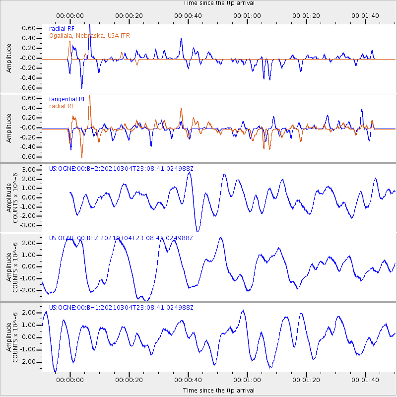
OGNE Ogallala, Nebraska, USA - Earthquake Result Viewer
*The percent match for this event was below the threshold and hence no stack was calculated.
| Earthquake location: |
Kermadec Islands Region |
| Earthquake latitude/longitude: |
-28.9/-176.4 |
| Earthquake time(UTC): |
2021/03/04 (063) 22:55:37 GMT |
| Earthquake Depth: |
10 km |
| Earthquake Magnitude: |
5.6 mb |
| Earthquake Catalog/Contributor: |
NEIC PDE/us |
|
| Network: |
US United States National Seismic Network |
| Station: |
OGNE Ogallala, Nebraska, USA |
| Lat/Lon: |
40.95 N/102.03 W |
| Elevation: |
1054 m |
|
| Distance: |
97.7 deg |
| Az: |
47.403 deg |
| Baz: |
238.449 deg |
| Ray Param: |
$rayparam |
*The percent match for this event was below the threshold and hence was not used in the summary stack. |
|
| Radial Match: |
73.00236 % |
| Radial Bump: |
400 |
| Transverse Match: |
56.684685 % |
| Transverse Bump: |
400 |
| SOD ConfigId: |
23341671 |
| Insert Time: |
2021-03-19 00:19:17.809 +0000 |
| GWidth: |
2.5 |
| Max Bumps: |
400 |
| Tol: |
0.001 |
|
Signal To Noise
| Channel | StoN | STA | LTA |
| US:OGNE:00:BHZ:20210304T23:08:41.024988Z | 2.0409615 | 2.4032593E-6 | 1.1775134E-6 |
| US:OGNE:00:BH1:20210304T23:08:41.024988Z | 0.8040332 | 1.0858759E-6 | 1.350536E-6 |
| US:OGNE:00:BH2:20210304T23:08:41.024988Z | 0.9854925 | 7.4651024E-7 | 7.5749966E-7 |
| Arrivals |
| Ps | |
| PpPs | |
| PsPs/PpSs | |


