You are here: Home > Network List > IU - Global Seismograph Network (GSN - IRIS/USGS) Stations List
> Station RSSD Black Hills, South Dakota, USA > Earthquake Result Viewer
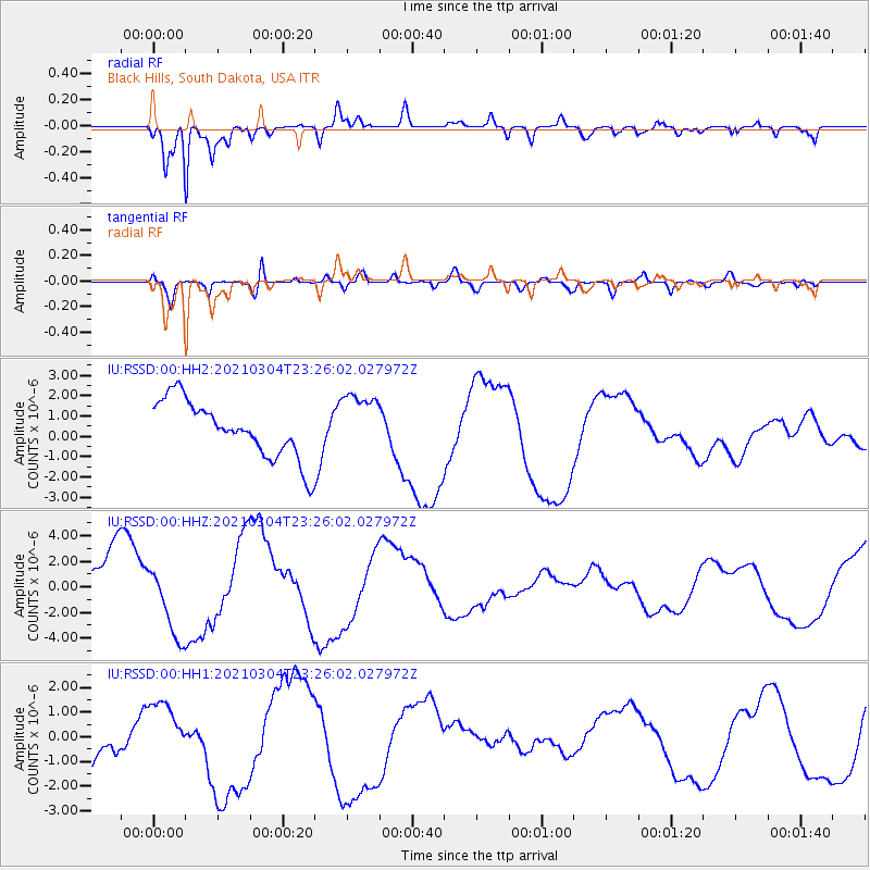
RSSD Black Hills, South Dakota, USA - Earthquake Result Viewer
*The percent match for this event was below the threshold and hence no stack was calculated.
| Earthquake location: |
Kermadec Islands Region |
| Earthquake latitude/longitude: |
-28.5/-176.6 |
| Earthquake time(UTC): |
2021/03/04 (063) 23:12:57 GMT |
| Earthquake Depth: |
10 km |
| Earthquake Magnitude: |
6.2 mb |
| Earthquake Catalog/Contributor: |
NEIC PDE/us |
|
| Network: |
IU Global Seismograph Network (GSN - IRIS/USGS) |
| Station: |
RSSD Black Hills, South Dakota, USA |
| Lat/Lon: |
44.12 N/104.04 W |
| Elevation: |
2090 m |
|
| Distance: |
98.0 deg |
| Az: |
43.944 deg |
| Baz: |
238.021 deg |
| Ray Param: |
$rayparam |
*The percent match for this event was below the threshold and hence was not used in the summary stack. |
|
| Radial Match: |
89.9289 % |
| Radial Bump: |
400 |
| Transverse Match: |
62.5492 % |
| Transverse Bump: |
400 |
| SOD ConfigId: |
23341671 |
| Insert Time: |
2021-03-19 00:29:07.740 +0000 |
| GWidth: |
2.5 |
| Max Bumps: |
400 |
| Tol: |
0.001 |
|
Signal To Noise
| Channel | StoN | STA | LTA |
| IU:RSSD:00:HHZ:20210304T23:26:02.027972Z | 1.2336495 | 3.0027627E-6 | 2.4340484E-6 |
| IU:RSSD:00:HH1:20210304T23:26:02.027972Z | 0.6859144 | 7.9212947E-7 | 1.1548518E-6 |
| IU:RSSD:00:HH2:20210304T23:26:02.027972Z | 1.111284 | 1.5426112E-6 | 1.388134E-6 |
| Arrivals |
| Ps | |
| PpPs | |
| PsPs/PpSs | |


