You are here: Home > Network List > NN - Western Great Basin/Eastern Sierra Nevada Stations List
> Station ZPR Zephyr Cove, Lake Tahoe, Nevada > Earthquake Result Viewer
ZPR Zephyr Cove, Lake Tahoe, Nevada - Earthquake Result Viewer
| Earthquake location: |
Kermadec Islands Region |
| Earthquake latitude/longitude: |
-28.5/-176.6 |
| Earthquake time(UTC): |
2021/03/04 (063) 23:12:57 GMT |
| Earthquake Depth: |
10 km |
| Earthquake Magnitude: |
6.2 mb |
| Earthquake Catalog/Contributor: |
NEIC PDE/us |
|
| Network: |
NN Western Great Basin/Eastern Sierra Nevada |
| Station: |
ZPR Zephyr Cove, Lake Tahoe, Nevada |
| Lat/Lon: |
39.01 N/119.94 W |
| Elevation: |
2001 m |
|
| Distance: |
85.5 deg |
| Az: |
40.773 deg |
| Baz: |
227.557 deg |
| Ray Param: |
0.04475724 |
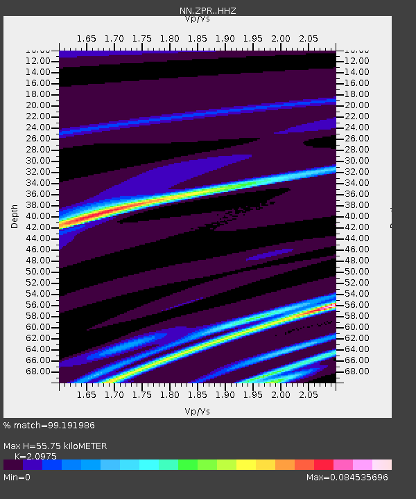
| Estimated Moho Depth: |
55.75 km |
| Estimated Crust Vp/Vs: |
2.10 |
| Assumed Crust Vp: |
6.279 km/s |
| Estimated Crust Vs: |
2.993 km/s |
| Estimated Crust Poisson's Ratio: |
0.35 |
|
| Radial Match: |
99.191986 % |
| Radial Bump: |
38 |
| Transverse Match: |
99.86817 % |
| Transverse Bump: |
13 |
| SOD ConfigId: |
23341671 |
| Insert Time: |
2021-03-19 00:30:09.806 +0000 |
| GWidth: |
2.5 |
| Max Bumps: |
400 |
| Tol: |
0.001 |
|

Signal To Noise
| Channel | StoN | STA | LTA |
| NN:ZPR: :HHZ:20210304T23:25:03.758014Z | 1.0674536 | 5.86996E-7 | 5.4990306E-7 |
| NN:ZPR: :HHN:20210304T23:25:03.758014Z | 1.0518701 | 7.2516985E-7 | 6.8941006E-7 |
| NN:ZPR: :HHE:20210304T23:25:03.758014Z | 0.85068417 | 1.0560086E-7 | 1.2413639E-7 |
| Arrivals |
| Ps | 9.9 SECOND |
| PpPs | 27 SECOND |
| PsPs/PpSs | 37 SECOND |


