You are here: Home > Network List > TA - USArray Transportable Network (new EarthScope stations) Stations List
> Station M31M Drury Creek, Yukon, CA > Earthquake Result Viewer
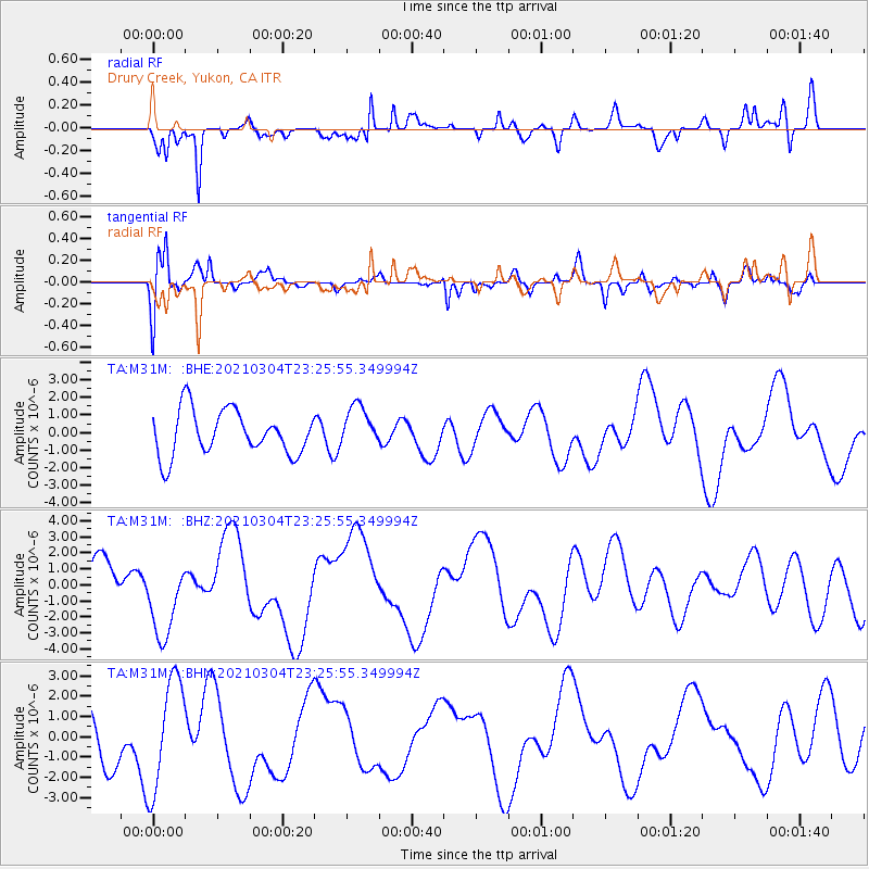
M31M Drury Creek, Yukon, CA - Earthquake Result Viewer
*The percent match for this event was below the threshold and hence no stack was calculated.
| Earthquake location: |
Kermadec Islands Region |
| Earthquake latitude/longitude: |
-28.5/-176.6 |
| Earthquake time(UTC): |
2021/03/04 (063) 23:12:57 GMT |
| Earthquake Depth: |
10 km |
| Earthquake Magnitude: |
6.2 mb |
| Earthquake Catalog/Contributor: |
NEIC PDE/us |
|
| Network: |
TA USArray Transportable Network (new EarthScope stations) |
| Station: |
M31M Drury Creek, Yukon, CA |
| Lat/Lon: |
62.20 N/134.39 W |
| Elevation: |
639 m |
|
| Distance: |
96.5 deg |
| Az: |
18.489 deg |
| Baz: |
216.548 deg |
| Ray Param: |
$rayparam |
*The percent match for this event was below the threshold and hence was not used in the summary stack. |
|
| Radial Match: |
84.15825 % |
| Radial Bump: |
400 |
| Transverse Match: |
76.57497 % |
| Transverse Bump: |
400 |
| SOD ConfigId: |
23341671 |
| Insert Time: |
2021-03-19 00:32:52.465 +0000 |
| GWidth: |
2.5 |
| Max Bumps: |
400 |
| Tol: |
0.001 |
|
Signal To Noise
| Channel | StoN | STA | LTA |
| TA:M31M: :BHZ:20210304T23:25:55.349994Z | 2.6712275 | 2.424497E-6 | 9.0763416E-7 |
| TA:M31M: :BHN:20210304T23:25:55.349994Z | 2.3618271 | 2.7445112E-6 | 1.1620289E-6 |
| TA:M31M: :BHE:20210304T23:25:55.349994Z | 0.9523981 | 1.2133391E-6 | 1.2739831E-6 |
| Arrivals |
| Ps | |
| PpPs | |
| PsPs/PpSs | |


