You are here: Home > Network List > GE - GEOFON Stations List
> Station EIL GII/GEOFON Station Eilat, Israel > Earthquake Result Viewer
EIL GII/GEOFON Station Eilat, Israel - Earthquake Result Viewer
| Earthquake location: |
Hokkaido, Japan Region |
| Earthquake latitude/longitude: |
43.8/145.0 |
| Earthquake time(UTC): |
1997/11/15 (319) 07:05:16 GMT |
| Earthquake Depth: |
161 km |
| Earthquake Magnitude: |
5.8 MB, 6.1 UNKNOWN, 6.1 MW |
| Earthquake Catalog/Contributor: |
WHDF/NEIC |
|
| Network: |
GE GEOFON |
| Station: |
EIL GII/GEOFON Station Eilat, Israel |
| Lat/Lon: |
29.67 N/34.95 E |
| Elevation: |
210 m |
|
| Distance: |
82.9 deg |
| Az: |
304.534 deg |
| Baz: |
43.253 deg |
| Ray Param: |
0.046187047 |
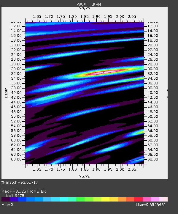
| Estimated Moho Depth: |
31.25 km |
| Estimated Crust Vp/Vs: |
1.93 |
| Assumed Crust Vp: |
6.472 km/s |
| Estimated Crust Vs: |
3.358 km/s |
| Estimated Crust Poisson's Ratio: |
0.32 |
|
| Radial Match: |
93.51717 % |
| Radial Bump: |
400 |
| Transverse Match: |
92.584854 % |
| Transverse Bump: |
400 |
| SOD ConfigId: |
6273 |
| Insert Time: |
2010-03-09 06:04:33.807 +0000 |
| GWidth: |
2.5 |
| Max Bumps: |
400 |
| Tol: |
0.001 |
|

Signal To Noise
| Channel | StoN | STA | LTA |
| GE:EIL: :BHN:19971115T07:16:52.118005Z | 7.3353014 | 3.4453464E-7 | 4.6969394E-8 |
| GE:EIL: :BHE:19971115T07:16:52.118005Z | 4.8194637 | 2.552603E-7 | 5.296446E-8 |
| GE:EIL: :BHZ:19971115T07:16:52.118005Z | 24.999723 | 1.5836667E-6 | 6.3347365E-8 |
| Arrivals |
| Ps | 4.6 SECOND |
| PpPs | 14 SECOND |
| PsPs/PpSs | 18 SECOND |


