You are here: Home > Network List > UU - University of Utah Regional Network Stations List
> Station FORU South Mineral Mountains, UT, USA > Earthquake Result Viewer
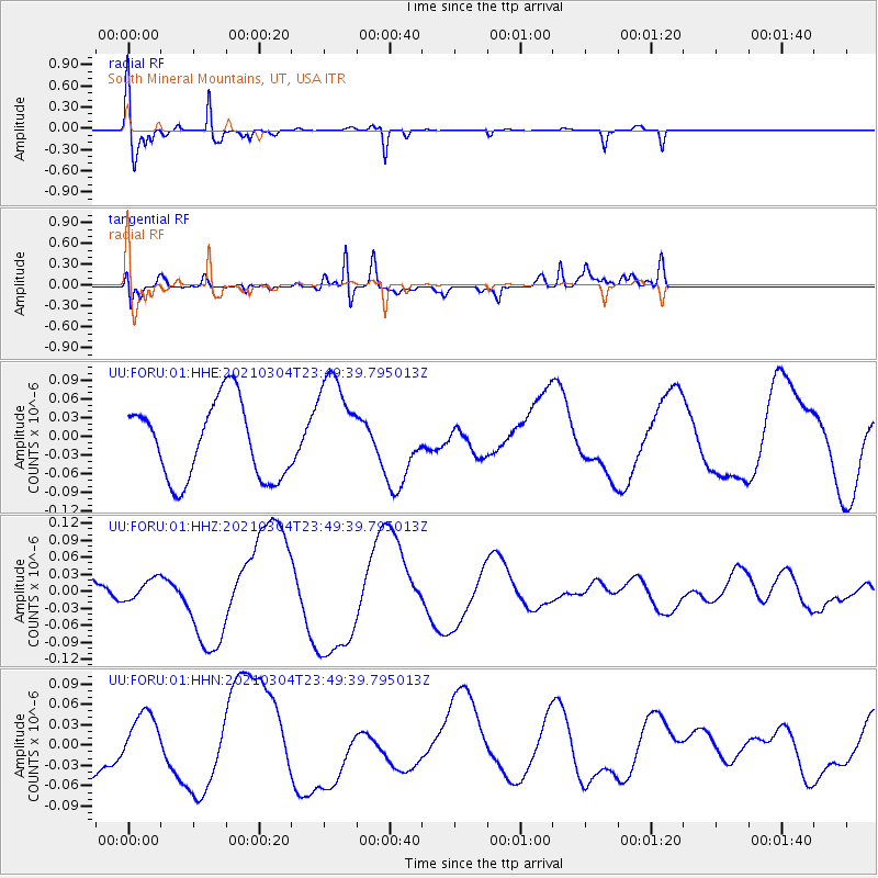
FORU South Mineral Mountains, UT, USA - Earthquake Result Viewer
*The percent match for this event was below the threshold and hence no stack was calculated.
| Earthquake location: |
Kermadec Islands, New Zealand |
| Earthquake latitude/longitude: |
-29.7/-177.2 |
| Earthquake time(UTC): |
2021/03/04 (063) 23:37:09 GMT |
| Earthquake Depth: |
10 km |
| Earthquake Magnitude: |
5.6 mb |
| Earthquake Catalog/Contributor: |
NEIC PDE/us |
|
| Network: |
UU University of Utah Regional Network |
| Station: |
FORU South Mineral Mountains, UT, USA |
| Lat/Lon: |
38.46 N/112.86 W |
| Elevation: |
1840 m |
|
| Distance: |
90.5 deg |
| Az: |
45.049 deg |
| Baz: |
231.678 deg |
| Ray Param: |
$rayparam |
*The percent match for this event was below the threshold and hence was not used in the summary stack. |
|
| Radial Match: |
79.09534 % |
| Radial Bump: |
276 |
| Transverse Match: |
76.05269 % |
| Transverse Bump: |
400 |
| SOD ConfigId: |
23341671 |
| Insert Time: |
2021-03-19 01:04:52.775 +0000 |
| GWidth: |
2.5 |
| Max Bumps: |
400 |
| Tol: |
0.001 |
|
Signal To Noise
| Channel | StoN | STA | LTA |
| UU:FORU:01:HHZ:20210304T23:49:39.795013Z | 0.30116063 | 1.798441E-8 | 5.9716996E-8 |
| UU:FORU:01:HHN:20210304T23:49:39.795013Z | 1.1441847 | 3.898716E-8 | 3.4074183E-8 |
| UU:FORU:01:HHE:20210304T23:49:39.795013Z | 1.4166522 | 8.6199115E-8 | 6.084705E-8 |
| Arrivals |
| Ps | |
| PpPs | |
| PsPs/PpSs | |


