You are here: Home > Network List > AV - Alaska Volcano Observatory Stations List
> Station MAPS Pakushin Southeast, Makushin Volcano, Alaska > Earthquake Result Viewer
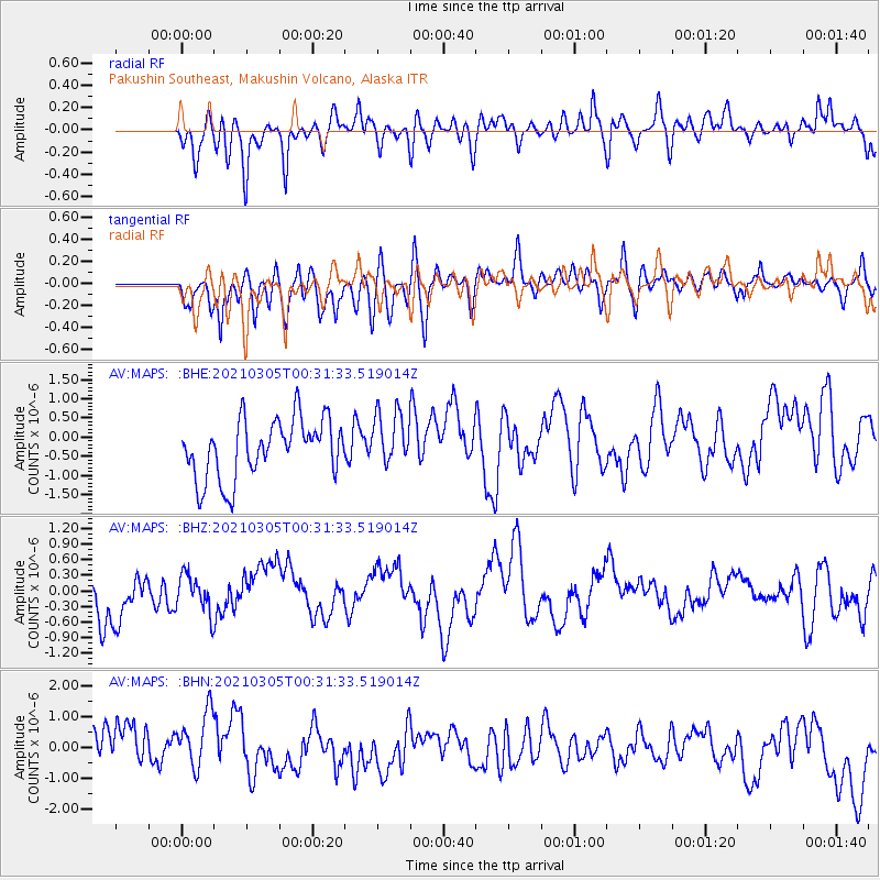
MAPS Pakushin Southeast, Makushin Volcano, Alaska - Earthquake Result Viewer
*The percent match for this event was below the threshold and hence no stack was calculated.
| Earthquake location: |
Kermadec Islands, New Zealand |
| Earthquake latitude/longitude: |
-29.2/-177.1 |
| Earthquake time(UTC): |
2021/03/05 (064) 00:19:39 GMT |
| Earthquake Depth: |
10 km |
| Earthquake Magnitude: |
5.6 mb |
| Earthquake Catalog/Contributor: |
NEIC PDE/us |
|
| Network: |
AV Alaska Volcano Observatory |
| Station: |
MAPS Pakushin Southeast, Makushin Volcano, Alaska |
| Lat/Lon: |
53.81 N/166.94 W |
| Elevation: |
333 m |
|
| Distance: |
83.1 deg |
| Az: |
6.028 deg |
| Baz: |
188.908 deg |
| Ray Param: |
$rayparam |
*The percent match for this event was below the threshold and hence was not used in the summary stack. |
|
| Radial Match: |
48.90543 % |
| Radial Bump: |
400 |
| Transverse Match: |
46.71094 % |
| Transverse Bump: |
400 |
| SOD ConfigId: |
23341671 |
| Insert Time: |
2021-03-19 01:24:29.693 +0000 |
| GWidth: |
2.5 |
| Max Bumps: |
400 |
| Tol: |
0.001 |
|
Signal To Noise
| Channel | StoN | STA | LTA |
| AV:MAPS: :BHZ:20210305T00:31:33.519014Z | 0.8911662 | 3.7084115E-7 | 4.1613018E-7 |
| AV:MAPS: :BHN:20210305T00:31:33.519014Z | 1.2567146 | 1.0294509E-6 | 8.1916045E-7 |
| AV:MAPS: :BHE:20210305T00:31:33.519014Z | 0.9584517 | 7.3534216E-7 | 7.672188E-7 |
| Arrivals |
| Ps | |
| PpPs | |
| PsPs/PpSs | |


