You are here: Home > Network List > CI - Caltech Regional Seismic Network Stations List
> Station FMP Fort MacArthur Park, Pt. Fermin San Pedro, CA, USA > Earthquake Result Viewer
FMP Fort MacArthur Park, Pt. Fermin San Pedro, CA, USA - Earthquake Result Viewer
| Earthquake location: |
Kermadec Islands, New Zealand |
| Earthquake latitude/longitude: |
-29.2/-177.1 |
| Earthquake time(UTC): |
2021/03/05 (064) 00:19:39 GMT |
| Earthquake Depth: |
10 km |
| Earthquake Magnitude: |
5.6 mb |
| Earthquake Catalog/Contributor: |
NEIC PDE/us |
|
| Network: |
CI Caltech Regional Seismic Network |
| Station: |
FMP Fort MacArthur Park, Pt. Fermin San Pedro, CA, USA |
| Lat/Lon: |
33.71 N/118.29 W |
| Elevation: |
89 m |
|
| Distance: |
83.7 deg |
| Az: |
45.817 deg |
| Baz: |
228.796 deg |
| Ray Param: |
0.046015624 |
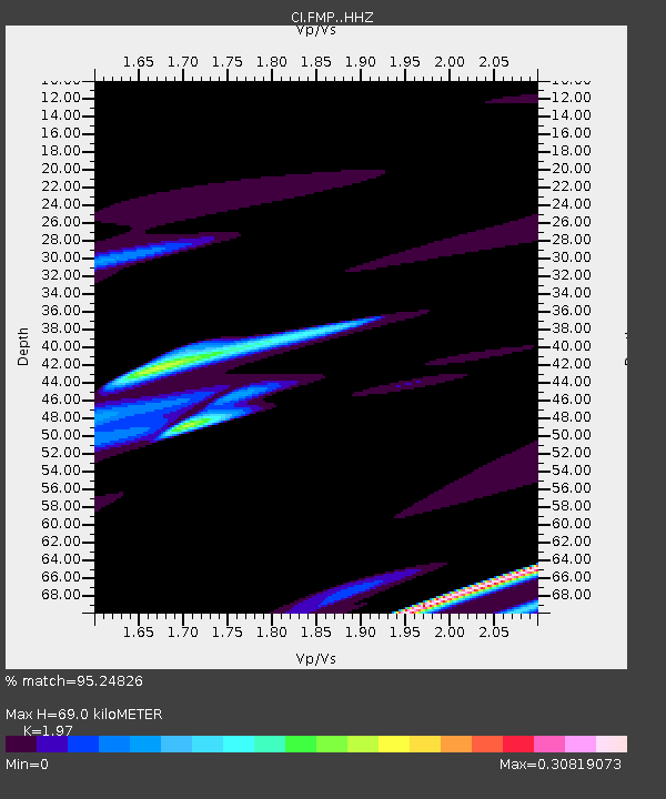
| Estimated Moho Depth: |
69.0 km |
| Estimated Crust Vp/Vs: |
1.97 |
| Assumed Crust Vp: |
6.048 km/s |
| Estimated Crust Vs: |
3.07 km/s |
| Estimated Crust Poisson's Ratio: |
0.33 |
|
| Radial Match: |
95.24826 % |
| Radial Bump: |
400 |
| Transverse Match: |
74.34863 % |
| Transverse Bump: |
400 |
| SOD ConfigId: |
23341671 |
| Insert Time: |
2021-03-19 01:27:14.276 +0000 |
| GWidth: |
2.5 |
| Max Bumps: |
400 |
| Tol: |
0.001 |
|
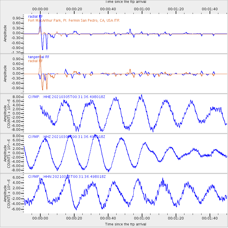
Signal To Noise
| Channel | StoN | STA | LTA |
| CI:FMP: :HHZ:20210305T00:31:36.498018Z | 1.3712946 | 5.110169E-6 | 3.726529E-6 |
| CI:FMP: :HHN:20210305T00:31:36.498018Z | 1.0867196 | 3.7493812E-6 | 3.4501827E-6 |
| CI:FMP: :HHE:20210305T00:31:36.498018Z | 1.2063899 | 4.9417895E-6 | 4.0963455E-6 |
| Arrivals |
| Ps | 11 SECOND |
| PpPs | 33 SECOND |
| PsPs/PpSs | 45 SECOND |


