You are here: Home > Network List > TA - USArray Transportable Network (new EarthScope stations) Stations List
> Station O17K Koliganek, Bristol Bay, AK, USA > Earthquake Result Viewer
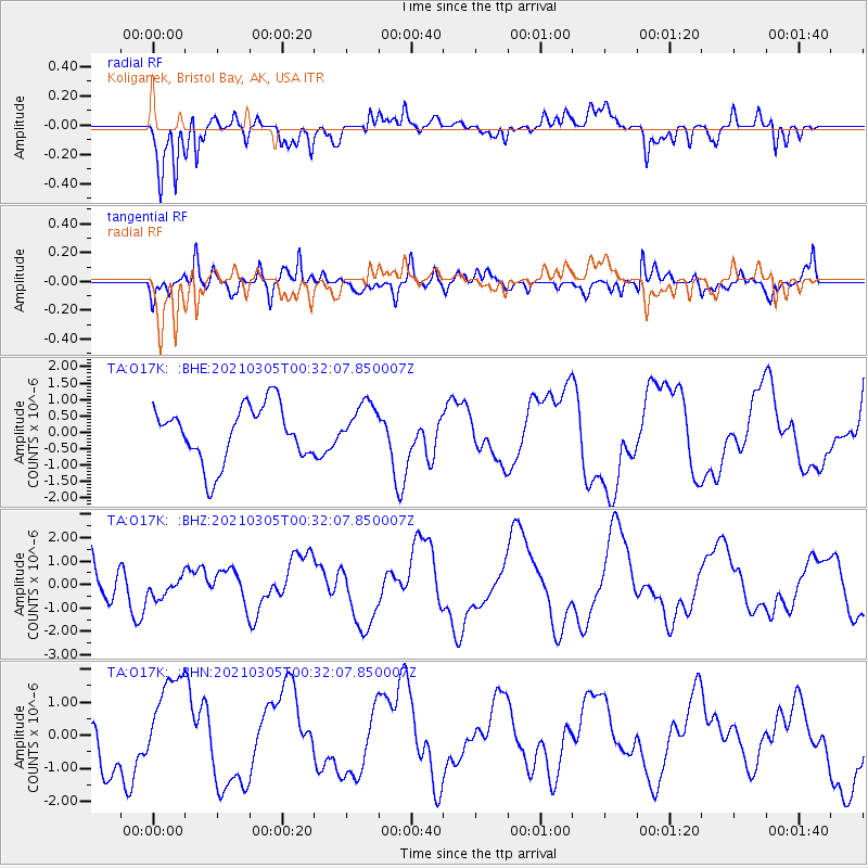
O17K Koliganek, Bristol Bay, AK, USA - Earthquake Result Viewer
*The percent match for this event was below the threshold and hence no stack was calculated.
| Earthquake location: |
Kermadec Islands, New Zealand |
| Earthquake latitude/longitude: |
-29.2/-177.1 |
| Earthquake time(UTC): |
2021/03/05 (064) 00:19:39 GMT |
| Earthquake Depth: |
10 km |
| Earthquake Magnitude: |
5.6 mb |
| Earthquake Catalog/Contributor: |
NEIC PDE/us |
|
| Network: |
TA USArray Transportable Network (new EarthScope stations) |
| Station: |
O17K Koliganek, Bristol Bay, AK, USA |
| Lat/Lon: |
59.77 N/157.09 W |
| Elevation: |
156 m |
|
| Distance: |
90.1 deg |
| Az: |
9.951 deg |
| Baz: |
197.378 deg |
| Ray Param: |
$rayparam |
*The percent match for this event was below the threshold and hence was not used in the summary stack. |
|
| Radial Match: |
76.028694 % |
| Radial Bump: |
395 |
| Transverse Match: |
77.334404 % |
| Transverse Bump: |
346 |
| SOD ConfigId: |
23341671 |
| Insert Time: |
2021-03-19 01:32:57.783 +0000 |
| GWidth: |
2.5 |
| Max Bumps: |
400 |
| Tol: |
0.001 |
|
Signal To Noise
| Channel | StoN | STA | LTA |
| TA:O17K: :BHZ:20210305T00:32:07.850007Z | 0.6539595 | 4.581873E-7 | 7.0063555E-7 |
| TA:O17K: :BHN:20210305T00:32:07.850007Z | 1.5833004 | 1.4969513E-6 | 9.4546266E-7 |
| TA:O17K: :BHE:20210305T00:32:07.850007Z | 0.821355 | 6.9534747E-7 | 8.4658575E-7 |
| Arrivals |
| Ps | |
| PpPs | |
| PsPs/PpSs | |


