You are here: Home > Network List > NM - Cooperative New Madrid Seismic Network Stations List
> Station UTMT Martin, TN > Earthquake Result Viewer
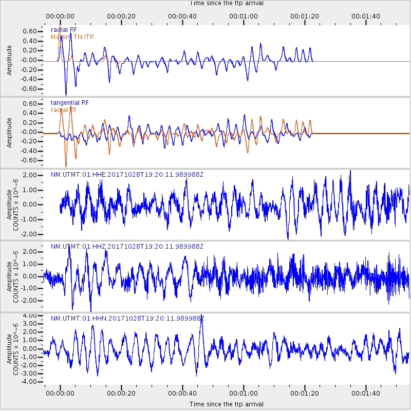
UTMT Martin, TN - Earthquake Result Viewer
*The percent match for this event was below the threshold and hence no stack was calculated.
| Earthquake location: |
North Of Franz Josef Land |
| Earthquake latitude/longitude: |
86.9/55.1 |
| Earthquake time(UTC): |
2017/10/28 (301) 19:11:01 GMT |
| Earthquake Depth: |
10 km |
| Earthquake Magnitude: |
6.0 Mww |
| Earthquake Catalog/Contributor: |
NEIC PDE/us |
|
| Network: |
NM Cooperative New Madrid Seismic Network |
| Station: |
UTMT Martin, TN |
| Lat/Lon: |
36.35 N/88.86 W |
| Elevation: |
110 m |
|
| Distance: |
56.4 deg |
| Az: |
325.261 deg |
| Baz: |
2.207 deg |
| Ray Param: |
$rayparam |
*The percent match for this event was below the threshold and hence was not used in the summary stack. |
|
| Radial Match: |
80.073555 % |
| Radial Bump: |
293 |
| Transverse Match: |
74.28504 % |
| Transverse Bump: |
400 |
| SOD ConfigId: |
2364251 |
| Insert Time: |
2017-11-11 19:15:21.631 +0000 |
| GWidth: |
2.5 |
| Max Bumps: |
400 |
| Tol: |
0.001 |
|
Signal To Noise
| Channel | StoN | STA | LTA |
| NM:UTMT:01:HHZ:20171028T19:20:11.989988Z | 2.2808483 | 1.1877399E-6 | 5.207449E-7 |
| NM:UTMT:01:HHN:20171028T19:20:11.989988Z | 2.0270562 | 9.347563E-7 | 4.6113985E-7 |
| NM:UTMT:01:HHE:20171028T19:20:11.989988Z | 0.6888187 | 4.5635286E-7 | 6.625152E-7 |
| Arrivals |
| Ps | |
| PpPs | |
| PsPs/PpSs | |


