You are here: Home > Network List > AK - Alaska Regional Network Stations List
> Station M19K Big River Lodge, Big River, AK, USA > Earthquake Result Viewer
M19K Big River Lodge, Big River, AK, USA - Earthquake Result Viewer
| Earthquake location: |
Kermadec Islands Region |
| Earthquake latitude/longitude: |
-29.0/-176.6 |
| Earthquake time(UTC): |
2021/03/05 (064) 00:28:19 GMT |
| Earthquake Depth: |
10 km |
| Earthquake Magnitude: |
5.9 mb |
| Earthquake Catalog/Contributor: |
NEIC PDE/us |
|
| Network: |
AK Alaska Regional Network |
| Station: |
M19K Big River Lodge, Big River, AK, USA |
| Lat/Lon: |
61.90 N/154.39 W |
| Elevation: |
521 m |
|
| Distance: |
92.3 deg |
| Az: |
10.298 deg |
| Baz: |
199.316 deg |
| Ray Param: |
0.041474745 |
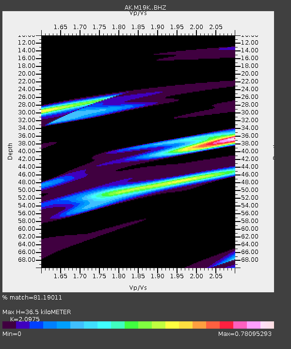
| Estimated Moho Depth: |
36.5 km |
| Estimated Crust Vp/Vs: |
2.10 |
| Assumed Crust Vp: |
6.566 km/s |
| Estimated Crust Vs: |
3.13 km/s |
| Estimated Crust Poisson's Ratio: |
0.35 |
|
| Radial Match: |
81.19011 % |
| Radial Bump: |
400 |
| Transverse Match: |
65.9897 % |
| Transverse Bump: |
400 |
| SOD ConfigId: |
23341671 |
| Insert Time: |
2021-03-19 01:37:05.347 +0000 |
| GWidth: |
2.5 |
| Max Bumps: |
400 |
| Tol: |
0.001 |
|

Signal To Noise
| Channel | StoN | STA | LTA |
| AK:M19K: :BHZ:20210305T00:40:57.939975Z | 1.6422256 | 2.325281E-6 | 1.4159327E-6 |
| AK:M19K: :BHN:20210305T00:40:57.939975Z | 1.0285002 | 7.814577E-7 | 7.598032E-7 |
| AK:M19K: :BHE:20210305T00:40:57.939975Z | 0.9294762 | 5.190947E-7 | 5.5848096E-7 |
| Arrivals |
| Ps | 6.2 SECOND |
| PpPs | 17 SECOND |
| PsPs/PpSs | 23 SECOND |


