You are here: Home > Network List > CI - Caltech Regional Seismic Network Stations List
> Station MPM Manuel Prospect Mine, California, USA > Earthquake Result Viewer
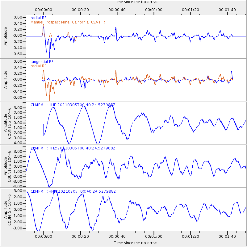
MPM Manuel Prospect Mine, California, USA - Earthquake Result Viewer
*The percent match for this event was below the threshold and hence no stack was calculated.
| Earthquake location: |
Kermadec Islands Region |
| Earthquake latitude/longitude: |
-29.0/-176.6 |
| Earthquake time(UTC): |
2021/03/05 (064) 00:28:19 GMT |
| Earthquake Depth: |
10 km |
| Earthquake Magnitude: |
5.9 mb |
| Earthquake Catalog/Contributor: |
NEIC PDE/us |
|
| Network: |
CI Caltech Regional Seismic Network |
| Station: |
MPM Manuel Prospect Mine, California, USA |
| Lat/Lon: |
36.06 N/117.49 W |
| Elevation: |
185 m |
|
| Distance: |
85.3 deg |
| Az: |
44.22 deg |
| Baz: |
228.933 deg |
| Ray Param: |
$rayparam |
*The percent match for this event was below the threshold and hence was not used in the summary stack. |
|
| Radial Match: |
94.11648 % |
| Radial Bump: |
383 |
| Transverse Match: |
83.4417 % |
| Transverse Bump: |
337 |
| SOD ConfigId: |
23341671 |
| Insert Time: |
2021-03-19 01:41:30.975 +0000 |
| GWidth: |
2.5 |
| Max Bumps: |
400 |
| Tol: |
0.001 |
|
Signal To Noise
| Channel | StoN | STA | LTA |
| CI:MPM: :HHZ:20210305T00:40:24.527988Z | 1.1011655 | 2.720529E-6 | 2.4705903E-6 |
| CI:MPM: :HHN:20210305T00:40:24.527988Z | 0.4558279 | 9.725716E-7 | 2.1336377E-6 |
| CI:MPM: :HHE:20210305T00:40:24.527988Z | 1.3128601 | 2.9518492E-6 | 2.248411E-6 |
| Arrivals |
| Ps | |
| PpPs | |
| PsPs/PpSs | |


