You are here: Home > Network List > GE - GEOFON Stations List
> Station EIL GEOFON Station Eilat, Israel > Earthquake Result Viewer
EIL GEOFON Station Eilat, Israel - Earthquake Result Viewer
| Earthquake location: |
Celebes Sea |
| Earthquake latitude/longitude: |
4.1/122.4 |
| Earthquake time(UTC): |
2009/10/07 (280) 21:41:13 GMT |
| Earthquake Depth: |
574 km |
| Earthquake Magnitude: |
6.3 MB, 6.8 MW, 6.8 MW |
| Earthquake Catalog/Contributor: |
WHDF/NEIC |
|
| Network: |
GE GEOFON |
| Station: |
EIL GEOFON Station Eilat, Israel |
| Lat/Lon: |
29.67 N/34.95 E |
| Elevation: |
210 m |
|
| Distance: |
85.8 deg |
| Az: |
299.33 deg |
| Baz: |
87.737 deg |
| Ray Param: |
0.0428831 |
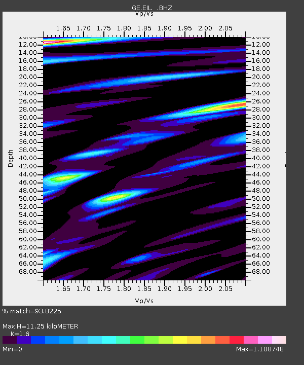
| Estimated Moho Depth: |
11.25 km |
| Estimated Crust Vp/Vs: |
1.60 |
| Assumed Crust Vp: |
6.472 km/s |
| Estimated Crust Vs: |
4.045 km/s |
| Estimated Crust Poisson's Ratio: |
0.18 |
|
| Radial Match: |
93.8225 % |
| Radial Bump: |
400 |
| Transverse Match: |
82.32024 % |
| Transverse Bump: |
400 |
| SOD ConfigId: |
2622 |
| Insert Time: |
2010-03-09 06:06:00.201 +0000 |
| GWidth: |
2.5 |
| Max Bumps: |
400 |
| Tol: |
0.001 |
|

Signal To Noise
| Channel | StoN | STA | LTA |
| GE:EIL: :BHZ:20091007T21:52:21.150005Z | 29.418642 | 2.0793616E-6 | 7.068177E-8 |
| GE:EIL: :BHN:20091007T21:52:21.150005Z | 0.71724373 | 7.4309085E-8 | 1.0360368E-7 |
| GE:EIL: :BHE:20091007T21:52:21.150005Z | 6.4082727 | 5.5258045E-7 | 8.622923E-8 |
| Arrivals |
| Ps | 1.1 SECOND |
| PpPs | 4.4 SECOND |
| PsPs/PpSs | 5.5 SECOND |


