You are here: Home > Network List > TA - USArray Transportable Network (new EarthScope stations) Stations List
> Station O17K Koliganek, Bristol Bay, AK, USA > Earthquake Result Viewer
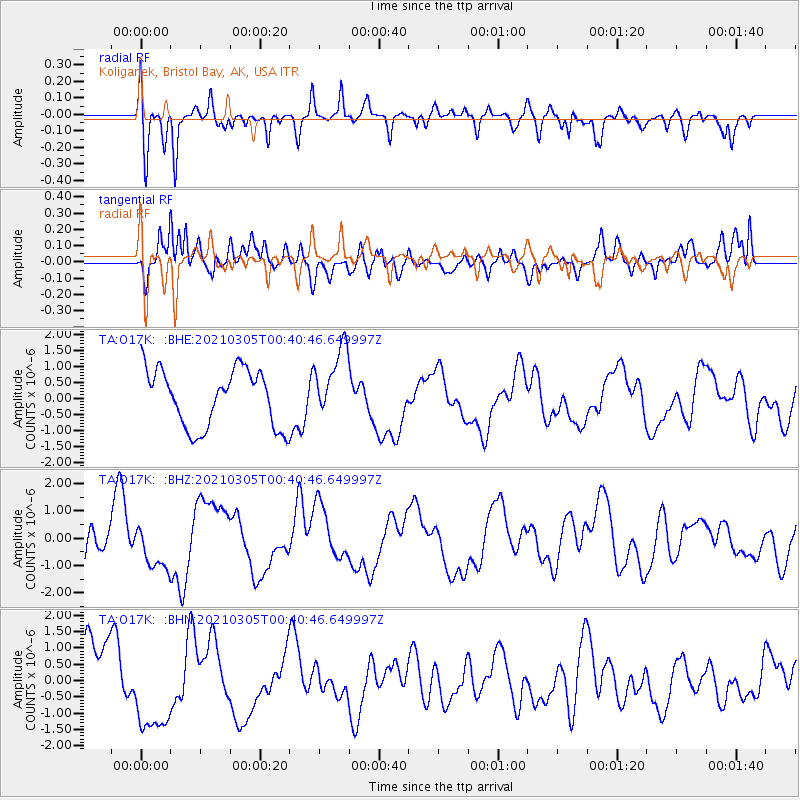
O17K Koliganek, Bristol Bay, AK, USA - Earthquake Result Viewer
*The percent match for this event was below the threshold and hence no stack was calculated.
| Earthquake location: |
Kermadec Islands Region |
| Earthquake latitude/longitude: |
-29.0/-176.6 |
| Earthquake time(UTC): |
2021/03/05 (064) 00:28:19 GMT |
| Earthquake Depth: |
10 km |
| Earthquake Magnitude: |
5.9 mb |
| Earthquake Catalog/Contributor: |
NEIC PDE/us |
|
| Network: |
TA USArray Transportable Network (new EarthScope stations) |
| Station: |
O17K Koliganek, Bristol Bay, AK, USA |
| Lat/Lon: |
59.77 N/157.09 W |
| Elevation: |
156 m |
|
| Distance: |
89.9 deg |
| Az: |
9.706 deg |
| Baz: |
196.97 deg |
| Ray Param: |
$rayparam |
*The percent match for this event was below the threshold and hence was not used in the summary stack. |
|
| Radial Match: |
67.55165 % |
| Radial Bump: |
400 |
| Transverse Match: |
72.04799 % |
| Transverse Bump: |
400 |
| SOD ConfigId: |
23341671 |
| Insert Time: |
2021-03-19 01:47:32.174 +0000 |
| GWidth: |
2.5 |
| Max Bumps: |
400 |
| Tol: |
0.001 |
|
Signal To Noise
| Channel | StoN | STA | LTA |
| TA:O17K: :BHZ:20210305T00:40:46.649997Z | 0.9049452 | 7.8809256E-7 | 8.7087324E-7 |
| TA:O17K: :BHN:20210305T00:40:46.649997Z | 1.3771281 | 1.4197036E-6 | 1.0309161E-6 |
| TA:O17K: :BHE:20210305T00:40:46.649997Z | 1.2467402 | 1.1126286E-6 | 8.924302E-7 |
| Arrivals |
| Ps | |
| PpPs | |
| PsPs/PpSs | |


