You are here: Home > Network List > TX - Texas Seismological Network Stations List
> Station HBVL Hebbronville > Earthquake Result Viewer
HBVL Hebbronville - Earthquake Result Viewer
| Earthquake location: |
Kermadec Islands Region |
| Earthquake latitude/longitude: |
-29.0/-176.6 |
| Earthquake time(UTC): |
2021/03/05 (064) 00:28:19 GMT |
| Earthquake Depth: |
10 km |
| Earthquake Magnitude: |
5.9 mb |
| Earthquake Catalog/Contributor: |
NEIC PDE/us |
|
| Network: |
TX Texas Seismological Network |
| Station: |
HBVL Hebbronville |
| Lat/Lon: |
27.06 N/98.67 W |
| Elevation: |
155 m |
|
| Distance: |
93.1 deg |
| Az: |
60.829 deg |
| Baz: |
239.064 deg |
| Ray Param: |
0.04133254 |
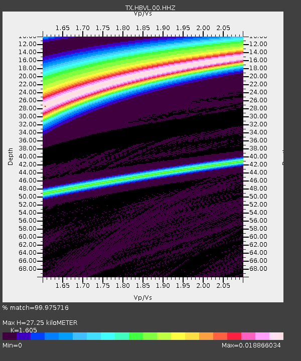
| Estimated Moho Depth: |
27.25 km |
| Estimated Crust Vp/Vs: |
1.61 |
| Assumed Crust Vp: |
6.096 km/s |
| Estimated Crust Vs: |
3.798 km/s |
| Estimated Crust Poisson's Ratio: |
0.18 |
|
| Radial Match: |
99.975716 % |
| Radial Bump: |
6 |
| Transverse Match: |
99.938156 % |
| Transverse Bump: |
10 |
| SOD ConfigId: |
23341671 |
| Insert Time: |
2021-03-19 01:48:18.262 +0000 |
| GWidth: |
2.5 |
| Max Bumps: |
400 |
| Tol: |
0.001 |
|

Signal To Noise
| Channel | StoN | STA | LTA |
| TX:HBVL:00:HHZ:20210305T00:41:01.514987Z | 0.24894398 | 8.746841E-9 | 3.513578E-8 |
| TX:HBVL:00:HH1:20210305T00:41:01.514987Z | 0.25074774 | 5.0234952E-8 | 2.003406E-7 |
| TX:HBVL:00:HH2:20210305T00:41:01.514987Z | 0.2469187 | 5.125459E-9 | 2.075768E-8 |
| Arrivals |
| Ps | 2.8 SECOND |
| PpPs | 11 SECOND |
| PsPs/PpSs | 14 SECOND |


