You are here: Home > Network List > AZ - ANZA Regional Network Stations List
> Station LVA2 AZ.LVA2 > Earthquake Result Viewer
LVA2 AZ.LVA2 - Earthquake Result Viewer

| Earthquake location: |
Kermadec Islands, New Zealand |
| Earthquake latitude/longitude: |
-30.1/-177.3 |
| Earthquake time(UTC): |
2021/03/05 (064) 00:58:27 GMT |
| Earthquake Depth: |
10 km |
| Earthquake Magnitude: |
5.6 mb |
| Earthquake Catalog/Contributor: |
NEIC PDE/us |
|
| Network: |
AZ ANZA Regional Network |
| Station: |
LVA2 AZ.LVA2 |
| Lat/Lon: |
33.35 N/116.56 W |
| Elevation: |
1435 m |
|
| Distance: |
85.3 deg |
| Az: |
47.127 deg |
| Baz: |
229.378 deg |
| Ray Param: |
0.04484797 |
| Estimated Moho Depth: |
10.75 km |
| Estimated Crust Vp/Vs: |
1.60 |
| Assumed Crust Vp: |
6.264 km/s |
| Estimated Crust Vs: |
3.915 km/s |
| Estimated Crust Poisson's Ratio: |
0.18 |
|
| Radial Match: |
93.273415 % |
| Radial Bump: |
352 |
| Transverse Match: |
75.09231 % |
| Transverse Bump: |
400 |
| SOD ConfigId: |
23341671 |
| Insert Time: |
2021-03-19 02:02:19.874 +0000 |
| GWidth: |
2.5 |
| Max Bumps: |
400 |
| Tol: |
0.001 |
|
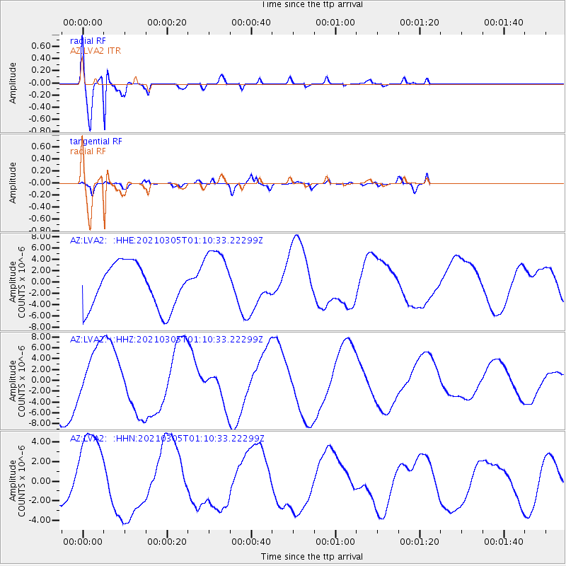
Signal To Noise
| Channel | StoN | STA | LTA |
| AZ:LVA2: :HHZ:20210305T01:10:33.22299Z | 0.9912388 | 5.0719536E-6 | 5.116783E-6 |
| AZ:LVA2: :HHN:20210305T01:10:33.22299Z | 1.8480744 | 4.4009616E-6 | 2.3813768E-6 |
| AZ:LVA2: :HHE:20210305T01:10:33.22299Z | 1.4567664 | 5.6127737E-6 | 3.852899E-6 |
| Arrivals |
| Ps | 1.1 SECOND |
| PpPs | 4.4 SECOND |
| PsPs/PpSs | 5.4 SECOND |


